You are here: Home > Network List > AZ - ANZA Regional Network Stations List
> Station MONP AZ.MONP > Earthquake Result Viewer
MONP AZ.MONP - Earthquake Result Viewer
| Earthquake location: |
Northwest Of Kuril Islands |
| Earthquake latitude/longitude: |
47.8/146.2 |
| Earthquake time(UTC): |
2002/11/17 (321) 04:53:53 GMT |
| Earthquake Depth: |
459 km |
| Earthquake Magnitude: |
7.3 MW, 7.3 MW |
| Earthquake Catalog/Contributor: |
WHDF/NEIC |
|
| Network: |
AZ ANZA Regional Network |
| Station: |
MONP AZ.MONP |
| Lat/Lon: |
32.89 N/116.42 W |
| Elevation: |
1920 m |
|
| Distance: |
70.9 deg |
| Az: |
61.984 deg |
| Baz: |
315.001 deg |
| Ray Param: |
0.05319078 |
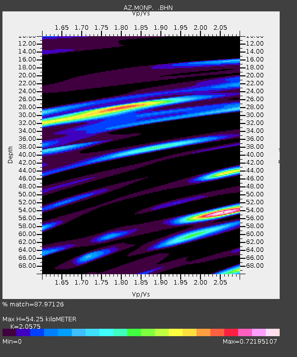
| Estimated Moho Depth: |
54.25 km |
| Estimated Crust Vp/Vs: |
2.06 |
| Assumed Crust Vp: |
6.264 km/s |
| Estimated Crust Vs: |
3.044 km/s |
| Estimated Crust Poisson's Ratio: |
0.35 |
|
| Radial Match: |
87.97126 % |
| Radial Bump: |
376 |
| Transverse Match: |
81.57885 % |
| Transverse Bump: |
400 |
| SOD ConfigId: |
4714 |
| Insert Time: |
2010-02-26 19:58:47.233 +0000 |
| GWidth: |
2.5 |
| Max Bumps: |
400 |
| Tol: |
0.001 |
|
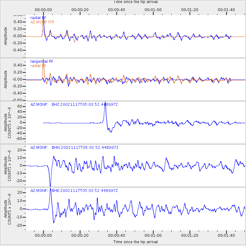
Signal To Noise
| Channel | StoN | STA | LTA |
| AZ:MONP: :BHN:20021117T05:03:52.448997Z | 24.86935 | 9.616825E-6 | 3.8669387E-7 |
| AZ:MONP: :BHE:20021117T05:03:52.448997Z | 20.289572 | 9.391105E-6 | 4.6285376E-7 |
| AZ:MONP: :BHZ:20021117T05:03:52.448997Z | 60.23141 | 2.7809147E-5 | 4.6170504E-7 |
| Arrivals |
| Ps | 9.4 SECOND |
| PpPs | 26 SECOND |
| PsPs/PpSs | 35 SECOND |


