You are here: Home > Network List > TA - USArray Transportable Network (new EarthScope stations) Stations List
> Station J34A George, IA, USA > Earthquake Result Viewer
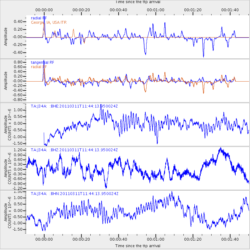
J34A George, IA, USA - Earthquake Result Viewer
*The percent match for this event was below the threshold and hence no stack was calculated.
| Earthquake location: |
Off East Coast Of Honshu, Japan |
| Earthquake latitude/longitude: |
36.2/142.4 |
| Earthquake time(UTC): |
2011/03/11 (070) 11:32:14 GMT |
| Earthquake Depth: |
35 km |
| Earthquake Magnitude: |
5.7 MB |
| Earthquake Catalog/Contributor: |
WHDF/NEIC |
|
| Network: |
TA USArray Transportable Network (new EarthScope stations) |
| Station: |
J34A George, IA, USA |
| Lat/Lon: |
43.28 N/95.96 W |
| Elevation: |
432 m |
|
| Distance: |
84.7 deg |
| Az: |
38.633 deg |
| Baz: |
316.275 deg |
| Ray Param: |
$rayparam |
*The percent match for this event was below the threshold and hence was not used in the summary stack. |
|
| Radial Match: |
47.838642 % |
| Radial Bump: |
293 |
| Transverse Match: |
57.516617 % |
| Transverse Bump: |
318 |
| SOD ConfigId: |
356183 |
| Insert Time: |
2011-08-15 07:30:44.708 +0000 |
| GWidth: |
2.5 |
| Max Bumps: |
400 |
| Tol: |
0.001 |
|
Signal To Noise
| Channel | StoN | STA | LTA |
| TA:J34A: :BHZ:20110311T11:44:13.950024Z | 0.783671 | 4.0180765E-7 | 5.127249E-7 |
| TA:J34A: :BHN:20110311T11:44:13.950024Z | 1.2042731 | 1.9224267E-6 | 1.5963378E-6 |
| TA:J34A: :BHE:20110311T11:44:13.950024Z | 2.5161932 | 1.1725149E-6 | 4.6598763E-7 |
| Arrivals |
| Ps | |
| PpPs | |
| PsPs/PpSs | |


