You are here: Home > Network List > AZ - ANZA Regional Network Stations List
> Station MONP AZ.MONP > Earthquake Result Viewer
MONP AZ.MONP - Earthquake Result Viewer
| Earthquake location: |
San Juan Province, Argentina |
| Earthquake latitude/longitude: |
-31.5/-69.2 |
| Earthquake time(UTC): |
2002/09/24 (267) 03:57:22 GMT |
| Earthquake Depth: |
120 km |
| Earthquake Magnitude: |
6.2 MB, 6.4 MW, 6.3 MW |
| Earthquake Catalog/Contributor: |
WHDF/NEIC |
|
| Network: |
AZ ANZA Regional Network |
| Station: |
MONP AZ.MONP |
| Lat/Lon: |
32.89 N/116.42 W |
| Elevation: |
1920 m |
|
| Distance: |
78.1 deg |
| Az: |
320.862 deg |
| Baz: |
140.156 deg |
| Ray Param: |
0.04961406 |
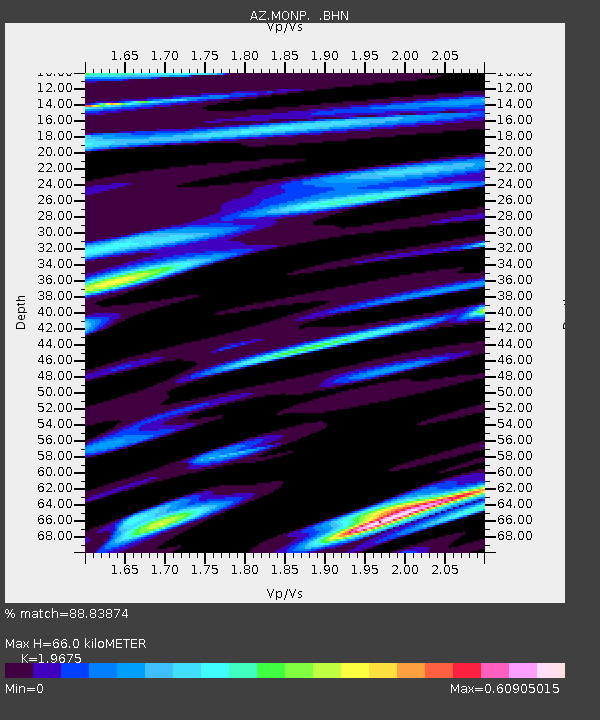
| Estimated Moho Depth: |
66.0 km |
| Estimated Crust Vp/Vs: |
1.97 |
| Assumed Crust Vp: |
6.264 km/s |
| Estimated Crust Vs: |
3.184 km/s |
| Estimated Crust Poisson's Ratio: |
0.33 |
|
| Radial Match: |
88.83874 % |
| Radial Bump: |
400 |
| Transverse Match: |
90.46488 % |
| Transverse Bump: |
400 |
| SOD ConfigId: |
4714 |
| Insert Time: |
2010-02-26 19:58:52.681 +0000 |
| GWidth: |
2.5 |
| Max Bumps: |
400 |
| Tol: |
0.001 |
|

Signal To Noise
| Channel | StoN | STA | LTA |
| AZ:MONP: :BHN:20020924T04:08:36.850007Z | 1.1359718 | 1.9511442E-7 | 1.7175991E-7 |
| AZ:MONP: :BHE:20020924T04:08:36.850007Z | 2.1242769 | 2.71781E-7 | 1.2794048E-7 |
| AZ:MONP: :BHZ:20020924T04:08:36.850007Z | 3.4786892 | 4.5244488E-7 | 1.3006188E-7 |
| Arrivals |
| Ps | 10 SECOND |
| PpPs | 30 SECOND |
| PsPs/PpSs | 41 SECOND |


