You are here: Home > Network List > AZ - ANZA Regional Network Stations List
> Station MONP AZ.MONP > Earthquake Result Viewer
MONP AZ.MONP - Earthquake Result Viewer
| Earthquake location: |
Northeastern China |
| Earthquake latitude/longitude: |
44.8/129.9 |
| Earthquake time(UTC): |
2002/09/15 (258) 08:39:32 GMT |
| Earthquake Depth: |
586 km |
| Earthquake Magnitude: |
5.8 MB, 6.4 MW, 6.4 MW |
| Earthquake Catalog/Contributor: |
WHDF/NEIC |
|
| Network: |
AZ ANZA Regional Network |
| Station: |
MONP AZ.MONP |
| Lat/Lon: |
32.89 N/116.42 W |
| Elevation: |
1920 m |
|
| Distance: |
82.0 deg |
| Az: |
51.103 deg |
| Baz: |
318.838 deg |
| Ray Param: |
0.04544826 |
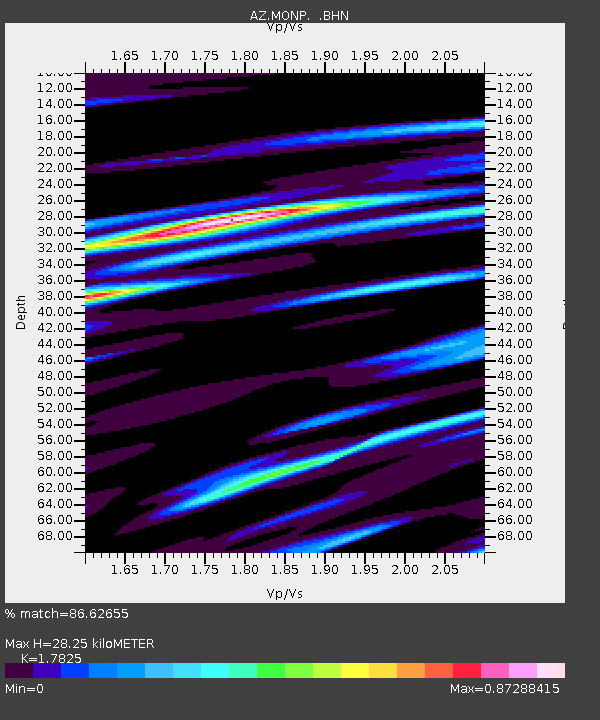
| Estimated Moho Depth: |
28.25 km |
| Estimated Crust Vp/Vs: |
1.78 |
| Assumed Crust Vp: |
6.264 km/s |
| Estimated Crust Vs: |
3.514 km/s |
| Estimated Crust Poisson's Ratio: |
0.27 |
|
| Radial Match: |
86.62655 % |
| Radial Bump: |
300 |
| Transverse Match: |
83.14742 % |
| Transverse Bump: |
400 |
| SOD ConfigId: |
4714 |
| Insert Time: |
2010-02-26 19:58:54.315 +0000 |
| GWidth: |
2.5 |
| Max Bumps: |
400 |
| Tol: |
0.001 |
|
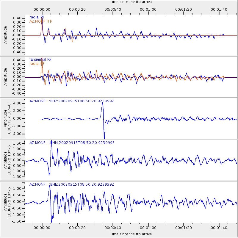
Signal To Noise
| Channel | StoN | STA | LTA |
| AZ:MONP: :BHN:20020915T08:50:20.923999Z | 8.446588 | 5.0240834E-7 | 5.9480634E-8 |
| AZ:MONP: :BHE:20020915T08:50:20.923999Z | 5.795348 | 4.7050986E-7 | 8.118751E-8 |
| AZ:MONP: :BHZ:20020915T08:50:20.923999Z | 15.0441 | 1.5842347E-6 | 1.0530605E-7 |
| Arrivals |
| Ps | 3.6 SECOND |
| PpPs | 12 SECOND |
| PsPs/PpSs | 16 SECOND |


