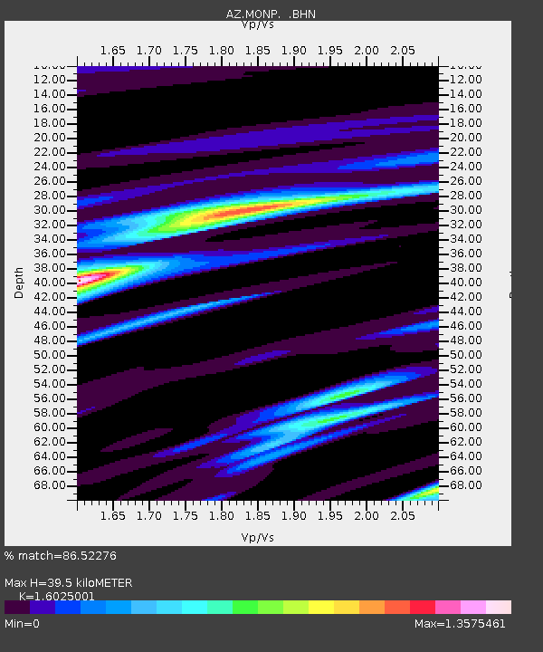
MONP AZ.MONP - Earthquake Result Viewer
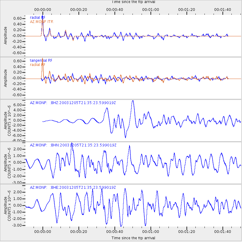
Earthquake location: Komandorskiye Ostrova Region
Earthquake latitude/longitude: 55.5/165.8
Earthquake time(UTC): 2003/12/05 (339) 21:26:09 GMT
Earthquake Depth: 10 km
Earthquake Magnitude: 6.1 MB, 6.5 MS, 6.7 MW, 6.7 MW
Earthquake Catalog/Contributor: WHDF/NEIC
Network: AZ ANZA Regional Network
Station: MONP AZ.MONP
Lat/Lon: 32.89 N/116.42 W
Elevation: 1920 m
Distance: 56.9 deg
Az: 78.927 deg
Baz: 318.467 deg
Ray Param: 0.06382404
Estimated Moho Depth: 39.5 km
Estimated Crust Vp/Vs: 1.60
Assumed Crust Vp: 6.264 km/s
Estimated Crust Vs: 3.909 km/s
Estimated Crust Poisson's Ratio: 0.18
Radial Match: 86.52276 %
Radial Bump: 400
Transverse Match: 77.58698 %
Transverse Bump: 400
SOD ConfigId: 32974
Insert Time: 2010-02-26 19:58:57.376 +0000
GWidth: 2.5
Max Bumps: 400
Tol: 0.001

Signal To Noise

ChannelStoNSTALTA
AZ:MONP: :BHN:20031205T21:35:23.599019Z1.55002816.1038736E-73.9379117E-7
AZ:MONP: :BHE:20031205T21:35:23.599019Z3.10856277.8464967E-72.524156E-7
AZ:MONP: :BHZ:20031205T21:35:23.599019Z2.76726321.2706557E-64.5917417E-7
Arrivals
Ps4.0 SECOND
PpPs16 SECOND
PsPs/PpSs20 SECOND