You are here: Home > Network List > US - United States National Seismic Network Stations List
> Station MNTX Cornudas Mountains, Texas, USA > Earthquake Result Viewer
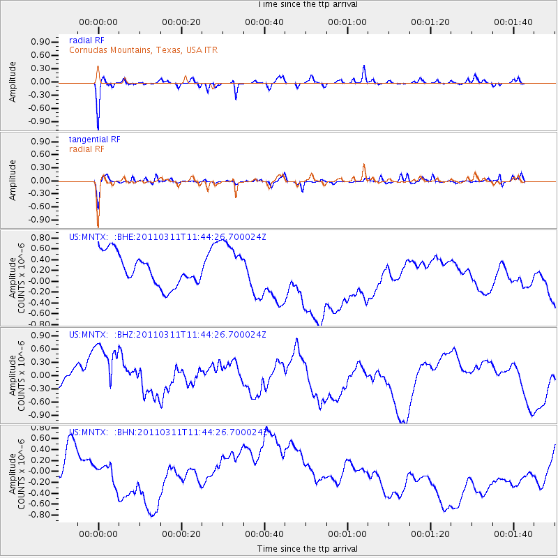
MNTX Cornudas Mountains, Texas, USA - Earthquake Result Viewer
*The percent match for this event was below the threshold and hence no stack was calculated.
| Earthquake location: |
Off East Coast Of Honshu, Japan |
| Earthquake latitude/longitude: |
36.2/142.4 |
| Earthquake time(UTC): |
2011/03/11 (070) 11:32:14 GMT |
| Earthquake Depth: |
35 km |
| Earthquake Magnitude: |
5.7 MB |
| Earthquake Catalog/Contributor: |
WHDF/NEIC |
|
| Network: |
US United States National Seismic Network |
| Station: |
MNTX Cornudas Mountains, Texas, USA |
| Lat/Lon: |
31.70 N/105.38 W |
| Elevation: |
404 m |
|
| Distance: |
87.3 deg |
| Az: |
52.182 deg |
| Baz: |
311.475 deg |
| Ray Param: |
$rayparam |
*The percent match for this event was below the threshold and hence was not used in the summary stack. |
|
| Radial Match: |
72.09438 % |
| Radial Bump: |
266 |
| Transverse Match: |
28.293087 % |
| Transverse Bump: |
240 |
| SOD ConfigId: |
356183 |
| Insert Time: |
2011-08-15 07:59:24.242 +0000 |
| GWidth: |
2.5 |
| Max Bumps: |
400 |
| Tol: |
0.001 |
|
Signal To Noise
| Channel | StoN | STA | LTA |
| US:MNTX: :BHZ:20110311T11:44:26.700024Z | 1.2385726 | 9.719768E-7 | 7.847555E-7 |
| US:MNTX: :BHN:20110311T11:44:26.700024Z | 0.3920233 | 3.122269E-7 | 7.964498E-7 |
| US:MNTX: :BHE:20110311T11:44:26.700024Z | 1.5440028 | 4.4053328E-7 | 2.8531898E-7 |
| Arrivals |
| Ps | |
| PpPs | |
| PsPs/PpSs | |


