You are here: Home > Network List > AZ - ANZA Regional Network Stations List
> Station MONP AZ.MONP > Earthquake Result Viewer
MONP AZ.MONP - Earthquake Result Viewer

| Earthquake location: |
Vanuatu Islands |
| Earthquake latitude/longitude: |
-19.3/168.9 |
| Earthquake time(UTC): |
2003/11/06 (310) 10:38:04 GMT |
| Earthquake Depth: |
114 km |
| Earthquake Magnitude: |
6.0 MB, 6.6 MW, 6.6 MW |
| Earthquake Catalog/Contributor: |
WHDF/NEIC |
|
| Network: |
AZ ANZA Regional Network |
| Station: |
MONP AZ.MONP |
| Lat/Lon: |
32.89 N/116.42 W |
| Elevation: |
1920 m |
|
| Distance: |
88.1 deg |
| Az: |
54.282 deg |
| Baz: |
245.734 deg |
| Ray Param: |
0.042575028 |
| Estimated Moho Depth: |
29.5 km |
| Estimated Crust Vp/Vs: |
1.83 |
| Assumed Crust Vp: |
6.264 km/s |
| Estimated Crust Vs: |
3.427 km/s |
| Estimated Crust Poisson's Ratio: |
0.29 |
|
| Radial Match: |
86.16694 % |
| Radial Bump: |
400 |
| Transverse Match: |
83.20129 % |
| Transverse Bump: |
400 |
| SOD ConfigId: |
32974 |
| Insert Time: |
2010-02-26 19:58:59.320 +0000 |
| GWidth: |
2.5 |
| Max Bumps: |
400 |
| Tol: |
0.001 |
|
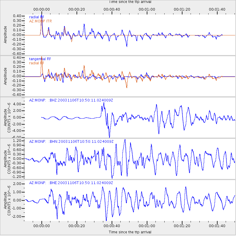
Signal To Noise
| Channel | StoN | STA | LTA |
| AZ:MONP: :BHN:20031106T10:50:11.024009Z | 0.76222163 | 1.15602404E-7 | 1.5166508E-7 |
| AZ:MONP: :BHE:20031106T10:50:11.024009Z | 1.5626416 | 3.1902994E-7 | 2.0416066E-7 |
| AZ:MONP: :BHZ:20031106T10:50:11.024009Z | 4.2822475 | 1.110693E-6 | 2.5937152E-7 |
| Arrivals |
| Ps | 4.0 SECOND |
| PpPs | 13 SECOND |
| PsPs/PpSs | 17 SECOND |


