You are here: Home > Network List > UW - Pacific Northwest Regional Seismic Network Stations List
> Station UMAT Pilot Rock, OR, USA > Earthquake Result Viewer
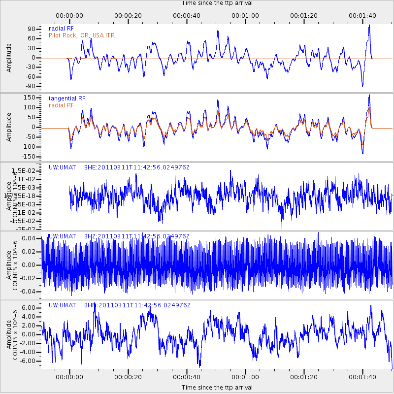
UMAT Pilot Rock, OR, USA - Earthquake Result Viewer
*The percent match for this event was below the threshold and hence no stack was calculated.
| Earthquake location: |
Off East Coast Of Honshu, Japan |
| Earthquake latitude/longitude: |
36.2/142.4 |
| Earthquake time(UTC): |
2011/03/11 (070) 11:32:14 GMT |
| Earthquake Depth: |
35 km |
| Earthquake Magnitude: |
5.7 MB |
| Earthquake Catalog/Contributor: |
WHDF/NEIC |
|
| Network: |
UW Pacific Northwest Regional Seismic Network |
| Station: |
UMAT Pilot Rock, OR, USA |
| Lat/Lon: |
45.29 N/118.96 W |
| Elevation: |
1318 m |
|
| Distance: |
70.7 deg |
| Az: |
47.697 deg |
| Baz: |
302.108 deg |
| Ray Param: |
$rayparam |
*The percent match for this event was below the threshold and hence was not used in the summary stack. |
|
| Radial Match: |
66.666245 % |
| Radial Bump: |
400 |
| Transverse Match: |
66.726295 % |
| Transverse Bump: |
400 |
| SOD ConfigId: |
356183 |
| Insert Time: |
2011-08-15 08:04:40.227 +0000 |
| GWidth: |
2.5 |
| Max Bumps: |
400 |
| Tol: |
0.001 |
|
Signal To Noise
| Channel | StoN | STA | LTA |
| UW:UMAT: :BHZ:20110311T11:42:56.024976Z | 1.0253693 | 1.9526555E-8 | 1.9043435E-8 |
| UW:UMAT: :BHN:20110311T11:42:56.024976Z | 0.7344717 | 1.7084748E-6 | 2.3261277E-6 |
| UW:UMAT: :BHE:20110311T11:42:56.024976Z | 1.7900186 | 7.752387E-9 | 4.330898E-9 |
| Arrivals |
| Ps | |
| PpPs | |
| PsPs/PpSs | |


