You are here: Home > Network List > AZ - ANZA Regional Network Stations List
> Station MONP AZ.MONP > Earthquake Result Viewer
MONP AZ.MONP - Earthquake Result Viewer

| Earthquake location: |
Primor'ye, Russia |
| Earthquake latitude/longitude: |
47.2/139.2 |
| Earthquake time(UTC): |
2003/07/27 (208) 06:25:31 GMT |
| Earthquake Depth: |
470 km |
| Earthquake Magnitude: |
6.3 MB, 6.8 MW, 6.8 MW |
| Earthquake Catalog/Contributor: |
WHDF/NEIC |
|
| Network: |
AZ ANZA Regional Network |
| Station: |
MONP AZ.MONP |
| Lat/Lon: |
32.89 N/116.42 W |
| Elevation: |
1920 m |
|
| Distance: |
75.4 deg |
| Az: |
57.412 deg |
| Baz: |
316.882 deg |
| Ray Param: |
0.050292972 |
| Estimated Moho Depth: |
55.5 km |
| Estimated Crust Vp/Vs: |
1.98 |
| Assumed Crust Vp: |
6.264 km/s |
| Estimated Crust Vs: |
3.167 km/s |
| Estimated Crust Poisson's Ratio: |
0.33 |
|
| Radial Match: |
92.1808 % |
| Radial Bump: |
400 |
| Transverse Match: |
82.45342 % |
| Transverse Bump: |
400 |
| SOD ConfigId: |
32974 |
| Insert Time: |
2010-02-26 19:59:04.702 +0000 |
| GWidth: |
2.5 |
| Max Bumps: |
400 |
| Tol: |
0.001 |
|
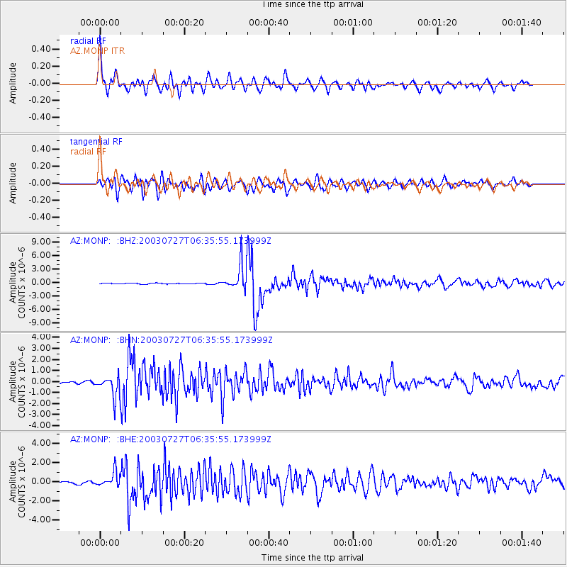
Signal To Noise
| Channel | StoN | STA | LTA |
| AZ:MONP: :BHN:20030727T06:35:55.173999Z | 9.096347 | 1.011197E-6 | 1.1116518E-7 |
| AZ:MONP: :BHE:20030727T06:35:55.173999Z | 3.9784002 | 8.103026E-7 | 2.0367548E-7 |
| AZ:MONP: :BHZ:20030727T06:35:55.173999Z | 30.520073 | 3.0902106E-6 | 1.0125174E-7 |
| Arrivals |
| Ps | 8.9 SECOND |
| PpPs | 26 SECOND |
| PsPs/PpSs | 35 SECOND |


