You are here: Home > Network List > KN - Kyrgyz Seismic Telemetry Network Stations List
> Station KBK KN.KBK > Earthquake Result Viewer
KBK KN.KBK - Earthquake Result Viewer
| Earthquake location: |
Off East Coast Of Honshu, Japan |
| Earthquake latitude/longitude: |
39.1/143.2 |
| Earthquake time(UTC): |
2011/03/11 (070) 11:32:27 GMT |
| Earthquake Depth: |
36 km |
| Earthquake Magnitude: |
5.8 MB |
| Earthquake Catalog/Contributor: |
WHDF/NEIC |
|
| Network: |
KN Kyrgyz Seismic Telemetry Network |
| Station: |
KBK KN.KBK |
| Lat/Lon: |
42.66 N/74.95 E |
| Elevation: |
1760 m |
|
| Distance: |
50.4 deg |
| Az: |
297.314 deg |
| Baz: |
69.661 deg |
| Ray Param: |
0.067977756 |
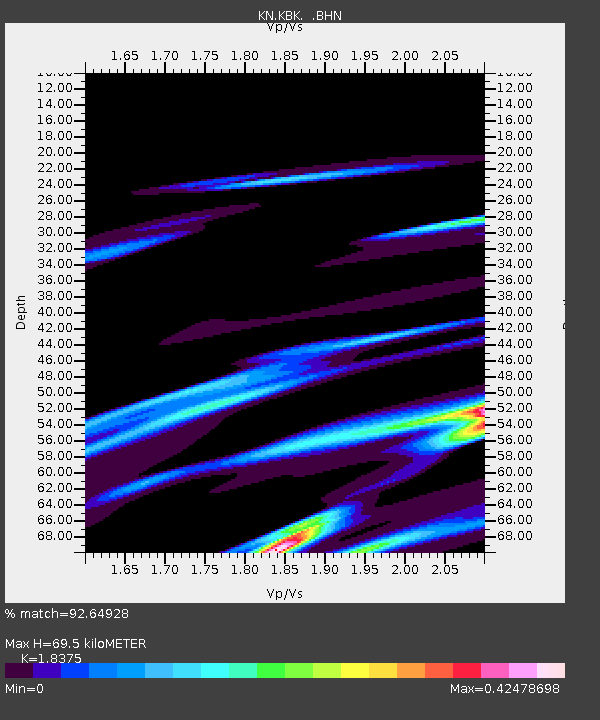
| Estimated Moho Depth: |
69.5 km |
| Estimated Crust Vp/Vs: |
1.84 |
| Assumed Crust Vp: |
6.306 km/s |
| Estimated Crust Vs: |
3.432 km/s |
| Estimated Crust Poisson's Ratio: |
0.29 |
|
| Radial Match: |
92.64928 % |
| Radial Bump: |
400 |
| Transverse Match: |
51.910786 % |
| Transverse Bump: |
400 |
| SOD ConfigId: |
356183 |
| Insert Time: |
2011-08-15 08:57:27.094 +0000 |
| GWidth: |
2.5 |
| Max Bumps: |
400 |
| Tol: |
0.001 |
|
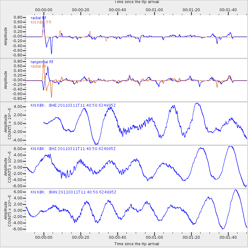
Signal To Noise
| Channel | StoN | STA | LTA |
| KN:KBK: :BHZ:20110311T11:40:50.624995Z | 2.7619956 | 4.488029E-6 | 1.6249227E-6 |
| KN:KBK: :BHN:20110311T11:40:50.624995Z | 0.3170843 | 6.135286E-7 | 1.934907E-6 |
| KN:KBK: :BHE:20110311T11:40:50.624995Z | 1.8934243 | 2.9817998E-6 | 1.5748186E-6 |
| Arrivals |
| Ps | 9.7 SECOND |
| PpPs | 30 SECOND |
| PsPs/PpSs | 39 SECOND |


