You are here: Home > Network List > AZ - ANZA Regional Network Stations List
> Station MONP AZ.MONP > Earthquake Result Viewer
MONP AZ.MONP - Earthquake Result Viewer

| Earthquake location: |
Mariana Islands |
| Earthquake latitude/longitude: |
14.5/147.0 |
| Earthquake time(UTC): |
2004/10/04 (278) 19:20:34 GMT |
| Earthquake Depth: |
7.2 km |
| Earthquake Magnitude: |
5.9 MB, 5.9 MS, 6.0 MW, 5.9 MW |
| Earthquake Catalog/Contributor: |
WHDF/NEIC |
|
| Network: |
AZ ANZA Regional Network |
| Station: |
MONP AZ.MONP |
| Lat/Lon: |
32.89 N/116.42 W |
| Elevation: |
1920 m |
|
| Distance: |
87.6 deg |
| Az: |
56.774 deg |
| Baz: |
285.678 deg |
| Ray Param: |
0.04319731 |
| Estimated Moho Depth: |
30.5 km |
| Estimated Crust Vp/Vs: |
1.82 |
| Assumed Crust Vp: |
6.264 km/s |
| Estimated Crust Vs: |
3.451 km/s |
| Estimated Crust Poisson's Ratio: |
0.28 |
|
| Radial Match: |
85.36333 % |
| Radial Bump: |
400 |
| Transverse Match: |
72.4752 % |
| Transverse Bump: |
400 |
| SOD ConfigId: |
2459 |
| Insert Time: |
2010-02-26 19:59:26.038 +0000 |
| GWidth: |
2.5 |
| Max Bumps: |
400 |
| Tol: |
0.001 |
|
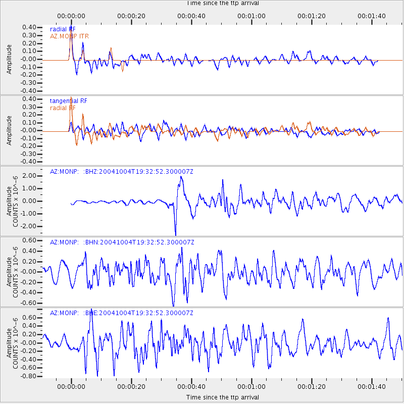
Signal To Noise
| Channel | StoN | STA | LTA |
| AZ:MONP: :BHN:20041004T19:32:52.300007Z | 2.5101547 | 1.9760833E-7 | 7.8723566E-8 |
| AZ:MONP: :BHE:20041004T19:32:52.300007Z | 1.6570902 | 1.8992918E-7 | 1.1461608E-7 |
| AZ:MONP: :BHZ:20041004T19:32:52.300007Z | 7.143461 | 7.085373E-7 | 9.918683E-8 |
| Arrivals |
| Ps | 4.1 SECOND |
| PpPs | 13 SECOND |
| PsPs/PpSs | 17 SECOND |


