You are here: Home > Network List > AZ - ANZA Regional Network Stations List
> Station MONP AZ.MONP > Earthquake Result Viewer
MONP AZ.MONP - Earthquake Result Viewer
| Earthquake location: |
Caribbean Sea |
| Earthquake latitude/longitude: |
19.0/-81.4 |
| Earthquake time(UTC): |
2004/12/14 (349) 23:20:13 GMT |
| Earthquake Depth: |
10 km |
| Earthquake Magnitude: |
6.2 MB, 6.7 MS, 6.8 MW, 6.8 MW |
| Earthquake Catalog/Contributor: |
WHDF/NEIC |
|
| Network: |
AZ ANZA Regional Network |
| Station: |
MONP AZ.MONP |
| Lat/Lon: |
32.89 N/116.42 W |
| Elevation: |
1920 m |
|
| Distance: |
34.2 deg |
| Az: |
300.909 deg |
| Baz: |
105.173 deg |
| Ray Param: |
0.07783882 |
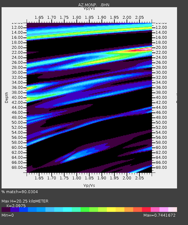
| Estimated Moho Depth: |
20.25 km |
| Estimated Crust Vp/Vs: |
2.10 |
| Assumed Crust Vp: |
6.264 km/s |
| Estimated Crust Vs: |
2.986 km/s |
| Estimated Crust Poisson's Ratio: |
0.35 |
|
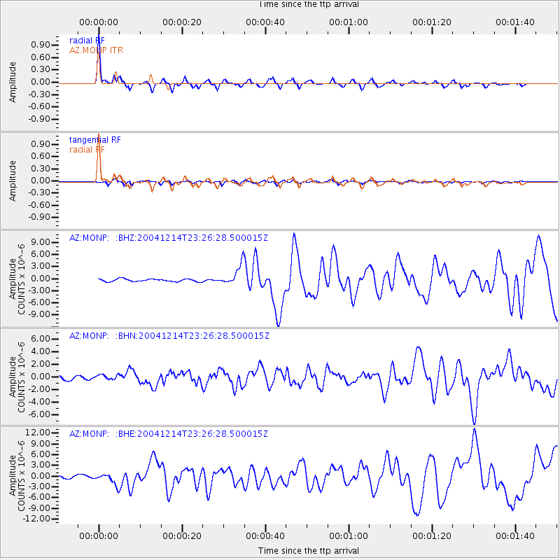
| Radial Match: |
90.0304 % |
| Radial Bump: |
400 |
| Transverse Match: |
70.692955 % |
| Transverse Bump: |
394 |
| SOD ConfigId: |
2459 |
| Insert Time: |
2010-02-26 19:59:30.852 +0000 |
| GWidth: |
2.5 |
| Max Bumps: |
400 |
| Tol: |
0.001 |
|
Signal To Noise
| Channel | StoN | STA | LTA |
| AZ:MONP: :BHN:20041214T23:26:28.500015Z | 1.2774423 | 3.7733136E-7 | 2.9538035E-7 |
| AZ:MONP: :BHE:20041214T23:26:28.500015Z | 4.5535855 | 1.587446E-6 | 3.4861455E-7 |
| AZ:MONP: :BHZ:20041214T23:26:28.500015Z | 8.253336 | 2.650427E-6 | 3.21134E-7 |
| Arrivals |
| Ps | 3.8 SECOND |
| PpPs | 9.4 SECOND |
| PsPs/PpSs | 13 SECOND |


