You are here: Home > Network List > TA - USArray Transportable Network (new EarthScope stations) Stations List
> Station U38A Gravette, AR, USA > Earthquake Result Viewer
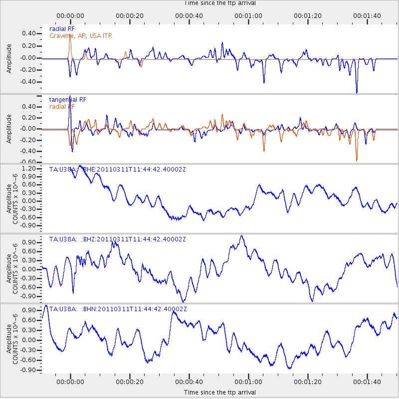
U38A Gravette, AR, USA - Earthquake Result Viewer
*The percent match for this event was below the threshold and hence no stack was calculated.
| Earthquake location: |
Off East Coast Of Honshu, Japan |
| Earthquake latitude/longitude: |
39.1/143.2 |
| Earthquake time(UTC): |
2011/03/11 (070) 11:32:27 GMT |
| Earthquake Depth: |
36 km |
| Earthquake Magnitude: |
5.8 MB |
| Earthquake Catalog/Contributor: |
WHDF/NEIC |
|
| Network: |
TA USArray Transportable Network (new EarthScope stations) |
| Station: |
U38A Gravette, AR, USA |
| Lat/Lon: |
36.44 N/94.39 W |
| Elevation: |
389 m |
|
| Distance: |
88.0 deg |
| Az: |
42.913 deg |
| Baz: |
318.902 deg |
| Ray Param: |
$rayparam |
*The percent match for this event was below the threshold and hence was not used in the summary stack. |
|
| Radial Match: |
46.566864 % |
| Radial Bump: |
309 |
| Transverse Match: |
62.386265 % |
| Transverse Bump: |
400 |
| SOD ConfigId: |
356183 |
| Insert Time: |
2011-08-15 09:51:33.277 +0000 |
| GWidth: |
2.5 |
| Max Bumps: |
400 |
| Tol: |
0.001 |
|
Signal To Noise
| Channel | StoN | STA | LTA |
| TA:U38A: :BHZ:20110311T11:44:42.40002Z | 1.8627071 | 6.661995E-7 | 3.5765123E-7 |
| TA:U38A: :BHN:20110311T11:44:42.40002Z | 0.8595036 | 8.784572E-7 | 1.0220517E-6 |
| TA:U38A: :BHE:20110311T11:44:42.40002Z | 2.017664 | 8.7898167E-7 | 4.3564324E-7 |
| Arrivals |
| Ps | |
| PpPs | |
| PsPs/PpSs | |


