You are here: Home > Network List > TA - USArray Transportable Network (new EarthScope stations) Stations List
> Station H37A Dierke Farm, Cannon Falls, MN, USA > Earthquake Result Viewer
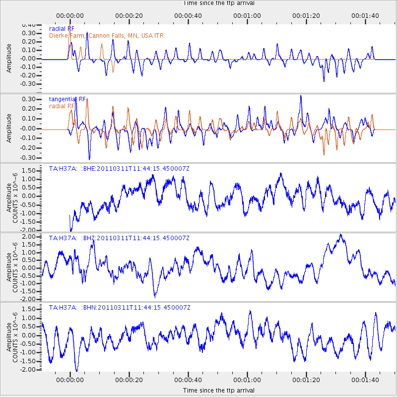
H37A Dierke Farm, Cannon Falls, MN, USA - Earthquake Result Viewer
*The percent match for this event was below the threshold and hence no stack was calculated.
| Earthquake location: |
Off East Coast Of Honshu, Japan |
| Earthquake latitude/longitude: |
39.1/143.2 |
| Earthquake time(UTC): |
2011/03/11 (070) 11:32:27 GMT |
| Earthquake Depth: |
36 km |
| Earthquake Magnitude: |
5.8 MB |
| Earthquake Catalog/Contributor: |
WHDF/NEIC |
|
| Network: |
TA USArray Transportable Network (new EarthScope stations) |
| Station: |
H37A Dierke Farm, Cannon Falls, MN, USA |
| Lat/Lon: |
44.58 N/92.92 W |
| Elevation: |
321 m |
|
| Distance: |
82.6 deg |
| Az: |
36.726 deg |
| Baz: |
319.349 deg |
| Ray Param: |
$rayparam |
*The percent match for this event was below the threshold and hence was not used in the summary stack. |
|
| Radial Match: |
57.553677 % |
| Radial Bump: |
334 |
| Transverse Match: |
49.26715 % |
| Transverse Bump: |
334 |
| SOD ConfigId: |
356183 |
| Insert Time: |
2011-08-15 09:59:17.455 +0000 |
| GWidth: |
2.5 |
| Max Bumps: |
400 |
| Tol: |
0.001 |
|
Signal To Noise
| Channel | StoN | STA | LTA |
| TA:H37A: :BHZ:20110311T11:44:15.450007Z | 2.185615 | 9.182363E-7 | 4.2012718E-7 |
| TA:H37A: :BHN:20110311T11:44:15.450007Z | 1.5104338 | 1.3833527E-6 | 9.1586446E-7 |
| TA:H37A: :BHE:20110311T11:44:15.450007Z | 1.4427389 | 9.556001E-7 | 6.6235134E-7 |
| Arrivals |
| Ps | |
| PpPs | |
| PsPs/PpSs | |


