You are here: Home > Network List > TA - USArray Transportable Network (new EarthScope stations) Stations List
> Station K37A Belmond, IA, USA > Earthquake Result Viewer
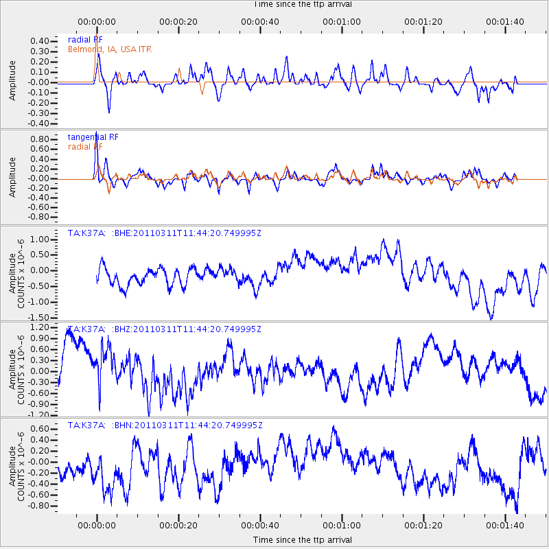
K37A Belmond, IA, USA - Earthquake Result Viewer
*The percent match for this event was below the threshold and hence no stack was calculated.
| Earthquake location: |
Off East Coast Of Honshu, Japan |
| Earthquake latitude/longitude: |
39.1/143.2 |
| Earthquake time(UTC): |
2011/03/11 (070) 11:32:27 GMT |
| Earthquake Depth: |
36 km |
| Earthquake Magnitude: |
5.8 MB |
| Earthquake Catalog/Contributor: |
WHDF/NEIC |
|
| Network: |
TA USArray Transportable Network (new EarthScope stations) |
| Station: |
K37A Belmond, IA, USA |
| Lat/Lon: |
42.77 N/93.64 W |
| Elevation: |
365 m |
|
| Distance: |
83.6 deg |
| Az: |
38.319 deg |
| Baz: |
319.043 deg |
| Ray Param: |
$rayparam |
*The percent match for this event was below the threshold and hence was not used in the summary stack. |
|
| Radial Match: |
42.36162 % |
| Radial Bump: |
331 |
| Transverse Match: |
46.792034 % |
| Transverse Bump: |
328 |
| SOD ConfigId: |
356183 |
| Insert Time: |
2011-08-15 10:02:21.728 +0000 |
| GWidth: |
2.5 |
| Max Bumps: |
400 |
| Tol: |
0.001 |
|
Signal To Noise
| Channel | StoN | STA | LTA |
| TA:K37A: :BHZ:20110311T11:44:20.749995Z | 0.92786586 | 5.220413E-7 | 5.6262587E-7 |
| TA:K37A: :BHN:20110311T11:44:20.749995Z | 1.3729448 | 9.432053E-7 | 6.869943E-7 |
| TA:K37A: :BHE:20110311T11:44:20.749995Z | 0.81620866 | 2.1952692E-7 | 2.689593E-7 |
| Arrivals |
| Ps | |
| PpPs | |
| PsPs/PpSs | |


