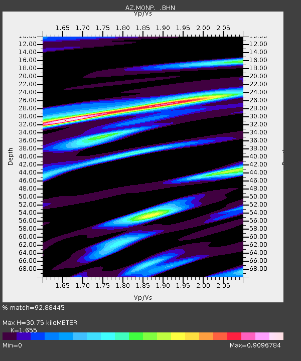
MONP AZ.MONP - Earthquake Result Viewer
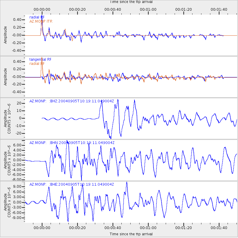
Earthquake location: Near S. Coast Of Western Honshu
Earthquake latitude/longitude: 33.1/136.6
Earthquake time(UTC): 2004/09/05 (249) 10:07:07 GMT
Earthquake Depth: 14 km
Earthquake Magnitude: 6.7 MB, 7.0 MS, 7.2 MW, 7.0 MW
Earthquake Catalog/Contributor: WHDF/NEIC
Network: AZ ANZA Regional Network
Station: MONP AZ.MONP
Lat/Lon: 32.89 N/116.42 W
Elevation: 1920 m
Distance: 85.0 deg
Az: 53.887 deg
Baz: 306.269 deg
Ray Param: 0.045085
Estimated Moho Depth: 30.75 km
Estimated Crust Vp/Vs: 1.65
Assumed Crust Vp: 6.264 km/s
Estimated Crust Vs: 3.785 km/s
Estimated Crust Poisson's Ratio: 0.21
Radial Match: 92.88445 %
Radial Bump: 400
Transverse Match: 80.71309 %
Transverse Bump: 400
SOD ConfigId: 2459
Insert Time: 2010-02-26 19:59:40.332 +0000
GWidth: 2.5
Max Bumps: 400
Tol: 0.001

Signal To Noise

ChannelStoNSTALTA
AZ:MONP: :BHN:20040905T10:19:11.049004Z5.9593872.7567442E-64.625886E-7
AZ:MONP: :BHE:20040905T10:19:11.049004Z5.618233.7086156E-66.601039E-7
AZ:MONP: :BHZ:20040905T10:19:11.049004Z11.46180251.0173655E-58.8761385E-7
Arrivals
Ps3.3 SECOND
PpPs13 SECOND
PsPs/PpSs16 SECOND