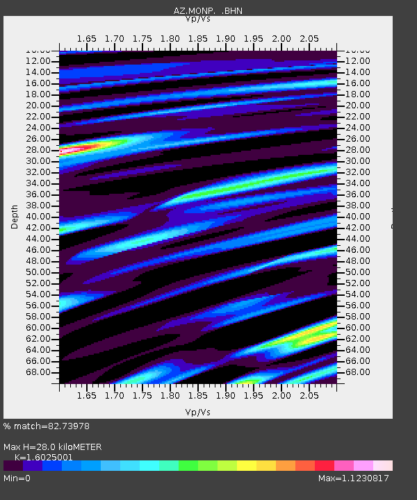
MONP AZ.MONP - Earthquake Result Viewer
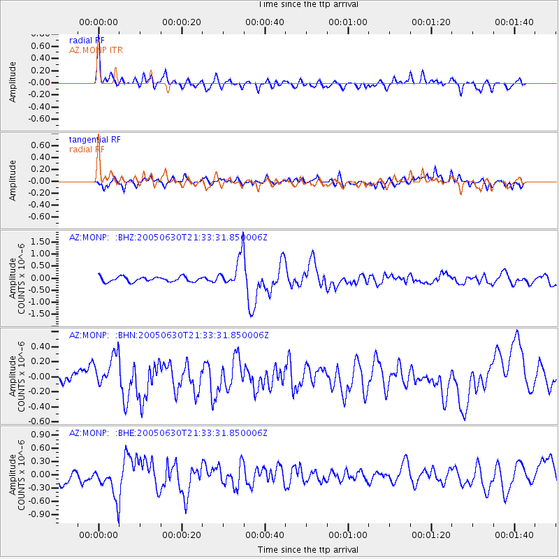
Earthquake location: Panama-Costa Rica Border Region
Earthquake latitude/longitude: 8.4/-82.9
Earthquake time(UTC): 2005/06/30 (181) 21:26:36 GMT
Earthquake Depth: 38 km
Earthquake Magnitude: 5.3 MB, 5.6 MS, 6.0 MW, 5.8 MW
Earthquake Catalog/Contributor: WHDF/NEIC
Network: AZ ANZA Regional Network
Station: MONP AZ.MONP
Lat/Lon: 32.89 N/116.42 W
Elevation: 1920 m
Distance: 39.4 deg
Az: 312.92 deg
Baz: 120.562 deg
Ray Param: 0.07491746
Estimated Moho Depth: 28.0 km
Estimated Crust Vp/Vs: 1.60
Assumed Crust Vp: 6.264 km/s
Estimated Crust Vs: 3.909 km/s
Estimated Crust Poisson's Ratio: 0.18
Radial Match: 82.73978 %
Radial Bump: 400
Transverse Match: 72.83643 %
Transverse Bump: 400
SOD ConfigId: 32974
Insert Time: 2010-02-26 19:59:52.381 +0000
GWidth: 2.5
Max Bumps: 400
Tol: 0.001

Signal To Noise

ChannelStoNSTALTA
AZ:MONP: :BHN:20050630T21:33:31.850006Z1.82234662.1508458E-71.18026165E-7
AZ:MONP: :BHE:20050630T21:33:31.850006Z3.19160413.7610502E-71.17842006E-7
AZ:MONP: :BHZ:20050630T21:33:31.850006Z6.62409976.8061297E-71.02748E-7
Arrivals
Ps2.9 SECOND
PpPs11 SECOND
PsPs/PpSs14 SECOND