You are here: Home > Network List > AV - Alaska Volcano Observatory Stations List
> Station SPCR Ckakachatna River, Mount Spurr, Alaska > Earthquake Result Viewer
SPCR Ckakachatna River, Mount Spurr, Alaska - Earthquake Result Viewer
| Earthquake location: |
Near East Coast Of Honshu, Japan |
| Earthquake latitude/longitude: |
39.2/142.5 |
| Earthquake time(UTC): |
2011/03/11 (070) 11:36:40 GMT |
| Earthquake Depth: |
26 km |
| Earthquake Magnitude: |
6.5 MB, 6.6 MS |
| Earthquake Catalog/Contributor: |
WHDF/NEIC |
|
| Network: |
AV Alaska Volcano Observatory |
| Station: |
SPCR Ckakachatna River, Mount Spurr, Alaska |
| Lat/Lon: |
61.20 N/152.21 W |
| Elevation: |
984 m |
|
| Distance: |
44.9 deg |
| Az: |
38.555 deg |
| Baz: |
271.744 deg |
| Ray Param: |
0.07158036 |
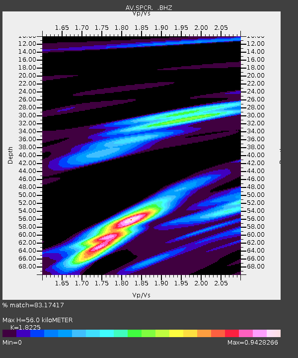
| Estimated Moho Depth: |
56.0 km |
| Estimated Crust Vp/Vs: |
1.82 |
| Assumed Crust Vp: |
6.566 km/s |
| Estimated Crust Vs: |
3.603 km/s |
| Estimated Crust Poisson's Ratio: |
0.28 |
|
| Radial Match: |
83.17417 % |
| Radial Bump: |
390 |
| Transverse Match: |
63.999645 % |
| Transverse Bump: |
397 |
| SOD ConfigId: |
356183 |
| Insert Time: |
2011-08-15 10:59:11.848 +0000 |
| GWidth: |
2.5 |
| Max Bumps: |
400 |
| Tol: |
0.001 |
|
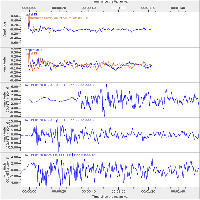
Signal To Noise
| Channel | StoN | STA | LTA |
| AV:SPCR: :BHZ:20110311T11:44:22.640001Z | 5.726978 | 4.280819E-6 | 7.4748317E-7 |
| AV:SPCR: :BHN:20110311T11:44:22.640001Z | 1.6261903 | 2.203377E-6 | 1.3549319E-6 |
| AV:SPCR: :BHE:20110311T11:44:22.640001Z | 2.5124714 | 1.8032163E-6 | 7.1770614E-7 |
| Arrivals |
| Ps | 7.5 SECOND |
| PpPs | 23 SECOND |
| PsPs/PpSs | 30 SECOND |


