You are here: Home > Network List > AZ - ANZA Regional Network Stations List
> Station MONP AZ.MONP > Earthquake Result Viewer
MONP AZ.MONP - Earthquake Result Viewer
| Earthquake location: |
Vanuatu Islands |
| Earthquake latitude/longitude: |
-14.3/167.3 |
| Earthquake time(UTC): |
2005/02/08 (039) 14:48:21 GMT |
| Earthquake Depth: |
206 km |
| Earthquake Magnitude: |
6.1 MB, 6.8 MW, 6.7 MW |
| Earthquake Catalog/Contributor: |
WHDF/NEIC |
|
| Network: |
AZ ANZA Regional Network |
| Station: |
MONP AZ.MONP |
| Lat/Lon: |
32.89 N/116.42 W |
| Elevation: |
1920 m |
|
| Distance: |
86.5 deg |
| Az: |
54.983 deg |
| Baz: |
250.707 deg |
| Ray Param: |
0.043503877 |
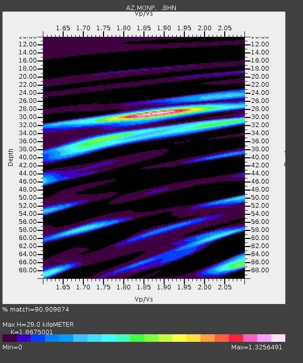
| Estimated Moho Depth: |
29.0 km |
| Estimated Crust Vp/Vs: |
1.87 |
| Assumed Crust Vp: |
6.264 km/s |
| Estimated Crust Vs: |
3.354 km/s |
| Estimated Crust Poisson's Ratio: |
0.30 |
|
| Radial Match: |
90.909874 % |
| Radial Bump: |
400 |
| Transverse Match: |
78.87534 % |
| Transverse Bump: |
400 |
| SOD ConfigId: |
5233 |
| Insert Time: |
2010-02-26 19:59:59.073 +0000 |
| GWidth: |
2.5 |
| Max Bumps: |
400 |
| Tol: |
0.001 |
|
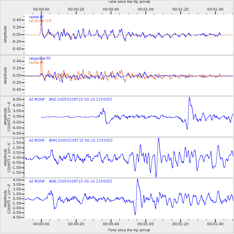
Signal To Noise
| Channel | StoN | STA | LTA |
| AZ:MONP: :BHN:20050208T15:00:10.225005Z | 0.6954198 | 1.9202702E-7 | 2.7613106E-7 |
| AZ:MONP: :BHE:20050208T15:00:10.225005Z | 2.6947472 | 5.71058E-7 | 2.1191524E-7 |
| AZ:MONP: :BHZ:20050208T15:00:10.225005Z | 5.6343803 | 9.918534E-7 | 1.7603593E-7 |
| Arrivals |
| Ps | 4.1 SECOND |
| PpPs | 13 SECOND |
| PsPs/PpSs | 17 SECOND |


