You are here: Home > Network List > IU - Global Seismograph Network (GSN - IRIS/USGS) Stations List
> Station FURI Mt. Furi, Ethiopia > Earthquake Result Viewer
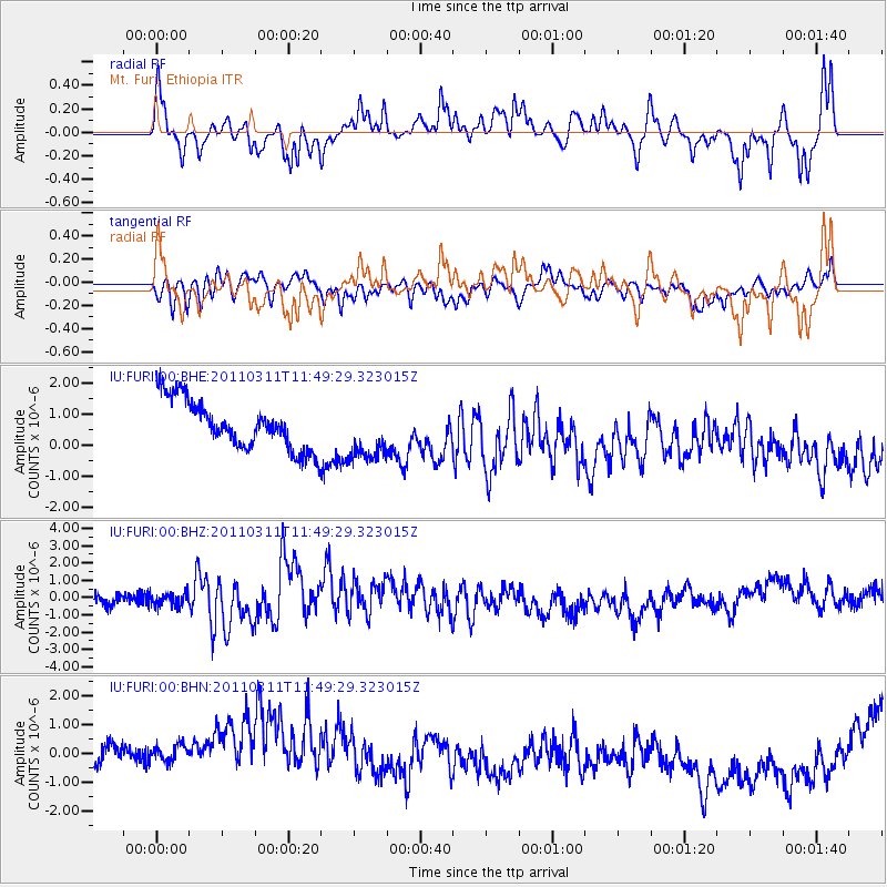
FURI Mt. Furi, Ethiopia - Earthquake Result Viewer
*The percent match for this event was below the threshold and hence no stack was calculated.
| Earthquake location: |
Near East Coast Of Honshu, Japan |
| Earthquake latitude/longitude: |
39.2/142.5 |
| Earthquake time(UTC): |
2011/03/11 (070) 11:36:40 GMT |
| Earthquake Depth: |
26 km |
| Earthquake Magnitude: |
6.5 MB, 6.6 MS |
| Earthquake Catalog/Contributor: |
WHDF/NEIC |
|
| Network: |
IU Global Seismograph Network (GSN - IRIS/USGS) |
| Station: |
FURI Mt. Furi, Ethiopia |
| Lat/Lon: |
8.90 N/38.68 E |
| Elevation: |
2570 m |
|
| Distance: |
94.9 deg |
| Az: |
285.582 deg |
| Baz: |
49.202 deg |
| Ray Param: |
$rayparam |
*The percent match for this event was below the threshold and hence was not used in the summary stack. |
|
| Radial Match: |
49.94434 % |
| Radial Bump: |
339 |
| Transverse Match: |
44.56049 % |
| Transverse Bump: |
353 |
| SOD ConfigId: |
356183 |
| Insert Time: |
2011-08-15 11:43:23.912 +0000 |
| GWidth: |
2.5 |
| Max Bumps: |
400 |
| Tol: |
0.001 |
|
Signal To Noise
| Channel | StoN | STA | LTA |
| IU:FURI:00:BHZ:20110311T11:49:29.323015Z | 0.99258333 | 4.414816E-7 | 4.447804E-7 |
| IU:FURI:00:BHN:20110311T11:49:29.323015Z | 0.96025157 | 1.1788131E-6 | 1.2276087E-6 |
| IU:FURI:00:BHE:20110311T11:49:29.323015Z | 1.1631597 | 9.197516E-7 | 7.907354E-7 |
| Arrivals |
| Ps | |
| PpPs | |
| PsPs/PpSs | |


