You are here: Home > Network List > AZ - ANZA Regional Network Stations List
> Station MONP AZ.MONP > Earthquake Result Viewer
MONP AZ.MONP - Earthquake Result Viewer

| Earthquake location: |
Nicaragua |
| Earthquake latitude/longitude: |
11.2/-85.5 |
| Earthquake time(UTC): |
2005/08/03 (215) 11:03:15 GMT |
| Earthquake Depth: |
14 km |
| Earthquake Magnitude: |
6.0 MB, 6.5 MS, 6.3 MW, 6.3 MW |
| Earthquake Catalog/Contributor: |
WHDF/NEIC |
|
| Network: |
AZ ANZA Regional Network |
| Station: |
MONP AZ.MONP |
| Lat/Lon: |
32.89 N/116.42 W |
| Elevation: |
1920 m |
|
| Distance: |
35.6 deg |
| Az: |
312.11 deg |
| Baz: |
120.113 deg |
| Ray Param: |
0.0771275 |
| Estimated Moho Depth: |
42.75 km |
| Estimated Crust Vp/Vs: |
1.60 |
| Assumed Crust Vp: |
6.264 km/s |
| Estimated Crust Vs: |
3.915 km/s |
| Estimated Crust Poisson's Ratio: |
0.18 |
|
| Radial Match: |
82.08774 % |
| Radial Bump: |
267 |
| Transverse Match: |
55.794365 % |
| Transverse Bump: |
400 |
| SOD ConfigId: |
2475 |
| Insert Time: |
2010-02-26 20:00:14.376 +0000 |
| GWidth: |
2.5 |
| Max Bumps: |
400 |
| Tol: |
0.001 |
|
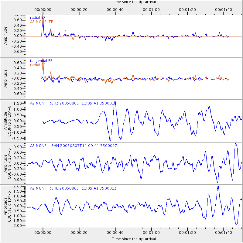
Signal To Noise
| Channel | StoN | STA | LTA |
| AZ:MONP: :BHN:20050803T11:09:41.350001Z | 2.4367557 | 1.5940036E-7 | 6.5414994E-8 |
| AZ:MONP: :BHE:20050803T11:09:41.350001Z | 4.565535 | 3.5880686E-7 | 7.8590325E-8 |
| AZ:MONP: :BHZ:20050803T11:09:41.350001Z | 5.8588085 | 5.628897E-7 | 9.6075794E-8 |
| Arrivals |
| Ps | 4.4 SECOND |
| PpPs | 16 SECOND |
| PsPs/PpSs | 21 SECOND |


