You are here: Home > Network List > AZ - ANZA Regional Network Stations List
> Station MONP AZ.MONP > Earthquake Result Viewer
MONP AZ.MONP - Earthquake Result Viewer

| Earthquake location: |
South Of Panama |
| Earthquake latitude/longitude: |
6.8/-82.4 |
| Earthquake time(UTC): |
2005/08/27 (239) 18:38:20 GMT |
| Earthquake Depth: |
10 km |
| Earthquake Magnitude: |
5.6 MB, 5.6 MS, 6.2 MW, 6.1 MW |
| Earthquake Catalog/Contributor: |
WHDF/NEIC |
|
| Network: |
AZ ANZA Regional Network |
| Station: |
MONP AZ.MONP |
| Lat/Lon: |
32.89 N/116.42 W |
| Elevation: |
1920 m |
|
| Distance: |
40.8 deg |
| Az: |
314.016 deg |
| Baz: |
121.919 deg |
| Ray Param: |
0.07415821 |
| Estimated Moho Depth: |
28.0 km |
| Estimated Crust Vp/Vs: |
1.60 |
| Assumed Crust Vp: |
6.264 km/s |
| Estimated Crust Vs: |
3.909 km/s |
| Estimated Crust Poisson's Ratio: |
0.18 |
|
| Radial Match: |
81.01331 % |
| Radial Bump: |
400 |
| Transverse Match: |
60.53177 % |
| Transverse Bump: |
400 |
| SOD ConfigId: |
2475 |
| Insert Time: |
2010-02-26 20:00:25.229 +0000 |
| GWidth: |
2.5 |
| Max Bumps: |
400 |
| Tol: |
0.001 |
|
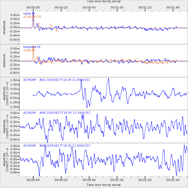
Signal To Noise
| Channel | StoN | STA | LTA |
| AZ:MONP: :BHN:20050827T18:45:31.899015Z | 1.207952 | 1.3847985E-7 | 1.14640194E-7 |
| AZ:MONP: :BHE:20050827T18:45:31.899015Z | 3.3803935 | 3.7469496E-7 | 1.10843594E-7 |
| AZ:MONP: :BHZ:20050827T18:45:31.899015Z | 4.1799345 | 5.8221354E-7 | 1.3928772E-7 |
| Arrivals |
| Ps | 2.9 SECOND |
| PpPs | 11 SECOND |
| PsPs/PpSs | 14 SECOND |


