You are here: Home > Network List > TA - USArray Transportable Network (new EarthScope stations) Stations List
> Station T31A Randall Ranch, Ashland, KS, USA > Earthquake Result Viewer
T31A Randall Ranch, Ashland, KS, USA - Earthquake Result Viewer
| Earthquake location: |
Near East Coast Of Honshu, Japan |
| Earthquake latitude/longitude: |
39.2/142.5 |
| Earthquake time(UTC): |
2011/03/11 (070) 11:36:40 GMT |
| Earthquake Depth: |
26 km |
| Earthquake Magnitude: |
6.5 MB, 6.6 MS |
| Earthquake Catalog/Contributor: |
WHDF/NEIC |
|
| Network: |
TA USArray Transportable Network (new EarthScope stations) |
| Station: |
T31A Randall Ranch, Ashland, KS, USA |
| Lat/Lon: |
37.10 N/99.68 W |
| Elevation: |
564 m |
|
| Distance: |
84.9 deg |
| Az: |
45.206 deg |
| Baz: |
316.429 deg |
| Ray Param: |
0.045094974 |
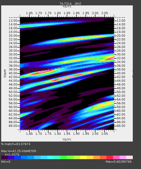
| Estimated Moho Depth: |
42.25 km |
| Estimated Crust Vp/Vs: |
1.84 |
| Assumed Crust Vp: |
6.426 km/s |
| Estimated Crust Vs: |
3.497 km/s |
| Estimated Crust Poisson's Ratio: |
0.29 |
|
| Radial Match: |
83.07674 % |
| Radial Bump: |
400 |
| Transverse Match: |
42.97269 % |
| Transverse Bump: |
336 |
| SOD ConfigId: |
356183 |
| Insert Time: |
2011-08-15 12:23:40.641 +0000 |
| GWidth: |
2.5 |
| Max Bumps: |
400 |
| Tol: |
0.001 |
|

Signal To Noise
| Channel | StoN | STA | LTA |
| TA:T31A: :BHZ:20110311T11:48:42.300005Z | 3.49896 | 1.8625921E-6 | 5.3232736E-7 |
| TA:T31A: :BHN:20110311T11:48:42.300005Z | 1.2257427 | 7.095114E-7 | 5.7884205E-7 |
| TA:T31A: :BHE:20110311T11:48:42.300005Z | 1.8355526 | 1.2203413E-6 | 6.6483597E-7 |
| Arrivals |
| Ps | 5.6 SECOND |
| PpPs | 18 SECOND |
| PsPs/PpSs | 24 SECOND |


