You are here: Home > Network List > TA - USArray Transportable Network (new EarthScope stations) Stations List
> Station G28A Parade, SD, USA > Earthquake Result Viewer
G28A Parade, SD, USA - Earthquake Result Viewer
| Earthquake location: |
Near East Coast Of Honshu, Japan |
| Earthquake latitude/longitude: |
39.2/142.5 |
| Earthquake time(UTC): |
2011/03/11 (070) 11:36:40 GMT |
| Earthquake Depth: |
26 km |
| Earthquake Magnitude: |
6.5 MB, 6.6 MS |
| Earthquake Catalog/Contributor: |
WHDF/NEIC |
|
| Network: |
TA USArray Transportable Network (new EarthScope stations) |
| Station: |
G28A Parade, SD, USA |
| Lat/Lon: |
45.07 N/100.92 W |
| Elevation: |
709 m |
|
| Distance: |
78.6 deg |
| Az: |
40.259 deg |
| Baz: |
314.906 deg |
| Ray Param: |
0.049515717 |
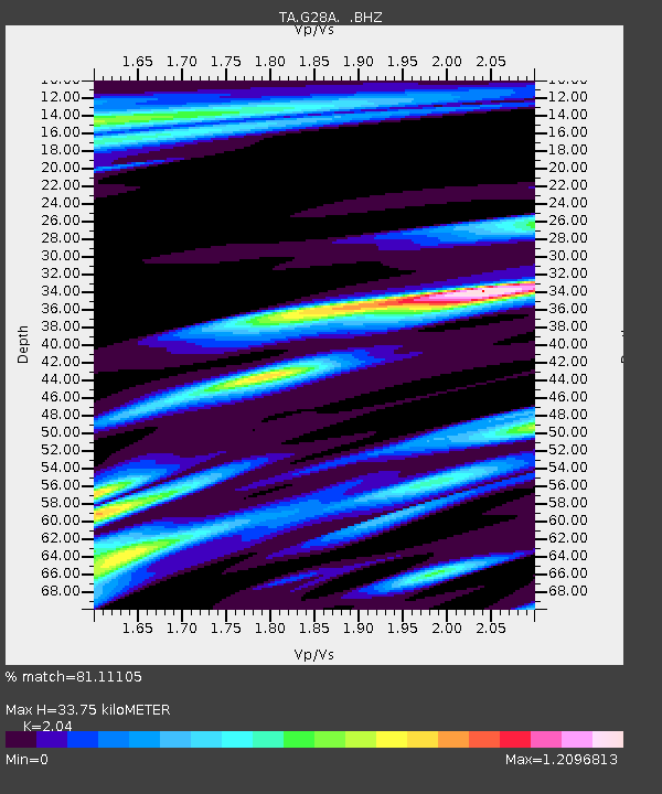
| Estimated Moho Depth: |
33.75 km |
| Estimated Crust Vp/Vs: |
2.04 |
| Assumed Crust Vp: |
6.53 km/s |
| Estimated Crust Vs: |
3.201 km/s |
| Estimated Crust Poisson's Ratio: |
0.34 |
|
| Radial Match: |
81.11105 % |
| Radial Bump: |
400 |
| Transverse Match: |
77.25186 % |
| Transverse Bump: |
400 |
| SOD ConfigId: |
356183 |
| Insert Time: |
2011-08-15 12:29:05.071 +0000 |
| GWidth: |
2.5 |
| Max Bumps: |
400 |
| Tol: |
0.001 |
|
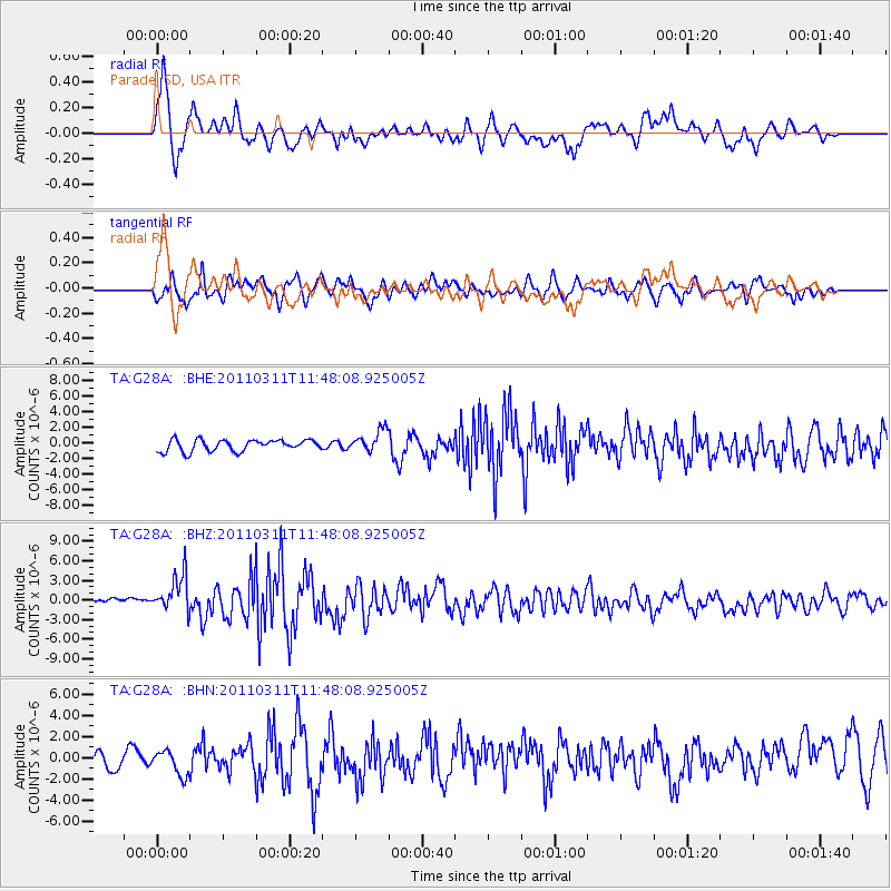
Signal To Noise
| Channel | StoN | STA | LTA |
| TA:G28A: :BHZ:20110311T11:48:08.925005Z | 4.160378 | 3.1186883E-6 | 7.4961656E-7 |
| TA:G28A: :BHN:20110311T11:48:08.925005Z | 1.6020281 | 1.2365153E-6 | 7.718437E-7 |
| TA:G28A: :BHE:20110311T11:48:08.925005Z | 1.9064875 | 1.4052943E-6 | 7.371117E-7 |
| Arrivals |
| Ps | 5.5 SECOND |
| PpPs | 15 SECOND |
| PsPs/PpSs | 21 SECOND |


