You are here: Home > Network List > IU - Global Seismograph Network (GSN - IRIS/USGS) Stations List
> Station MAKZ Makanchi, Kazakhstan > Earthquake Result Viewer
MAKZ Makanchi, Kazakhstan - Earthquake Result Viewer
*The percent match for this event was below the threshold and hence no stack was calculated.
| Earthquake location: |
Bonin Islands, Japan Region |
| Earthquake latitude/longitude: |
28.3/140.0 |
| Earthquake time(UTC): |
2014/02/10 (041) 08:37:51 GMT |
| Earthquake Depth: |
413 km |
| Earthquake Magnitude: |
4.7 mb |
| Earthquake Catalog/Contributor: |
ISC/ISC |
|
| Network: |
IU Global Seismograph Network (GSN - IRIS/USGS) |
| Station: |
MAKZ Makanchi, Kazakhstan |
| Lat/Lon: |
46.81 N/81.98 E |
| Elevation: |
600 m |
|
| Distance: |
48.4 deg |
| Az: |
308.882 deg |
| Baz: |
91.253 deg |
| Ray Param: |
$rayparam |
*The percent match for this event was below the threshold and hence was not used in the summary stack. |
|
| Radial Match: |
53.002636 % |
| Radial Bump: |
400 |
| Transverse Match: |
52.14234 % |
| Transverse Bump: |
400 |
| SOD ConfigId: |
3390531 |
| Insert Time: |
2019-04-10 07:01:40.200 +0000 |
| GWidth: |
2.5 |
| Max Bumps: |
400 |
| Tol: |
0.001 |
|
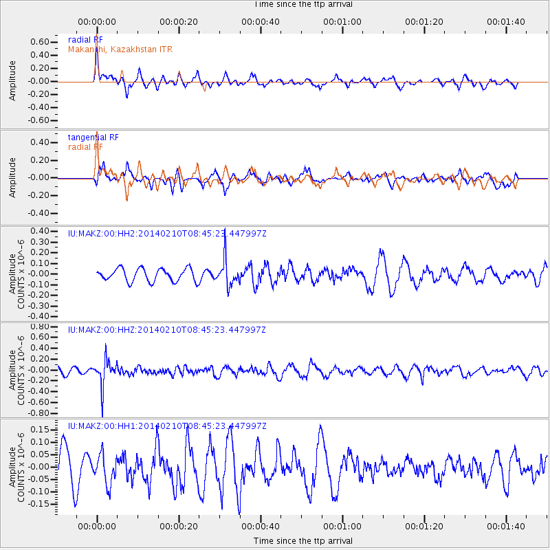
Signal To Noise
| Channel | StoN | STA | LTA |
| IU:MAKZ:00:HHZ:20140210T08:45:23.447997Z | 3.7694476 | 2.4178453E-7 | 6.414323E-8 |
| IU:MAKZ:00:HH1:20140210T08:45:23.447997Z | 0.97727495 | 5.8546725E-8 | 5.990814E-8 |
| IU:MAKZ:00:HH2:20140210T08:45:23.447997Z | 2.0552719 | 1.2317967E-7 | 5.993353E-8 |
| Arrivals |
| Ps | |
| PpPs | |
| PsPs/PpSs | |


