You are here: Home > Network List > TA - USArray Transportable Network (new EarthScope stations) Stations List
> Station B28A Dugan Ranch, Towner, ND, USA > Earthquake Result Viewer
B28A Dugan Ranch, Towner, ND, USA - Earthquake Result Viewer
| Earthquake location: |
Near East Coast Of Honshu, Japan |
| Earthquake latitude/longitude: |
39.2/142.5 |
| Earthquake time(UTC): |
2011/03/11 (070) 11:36:40 GMT |
| Earthquake Depth: |
26 km |
| Earthquake Magnitude: |
6.5 MB, 6.6 MS |
| Earthquake Catalog/Contributor: |
WHDF/NEIC |
|
| Network: |
TA USArray Transportable Network (new EarthScope stations) |
| Station: |
B28A Dugan Ranch, Towner, ND, USA |
| Lat/Lon: |
48.45 N/100.36 W |
| Elevation: |
451 m |
|
| Distance: |
76.5 deg |
| Az: |
37.531 deg |
| Baz: |
314.719 deg |
| Ray Param: |
0.050942365 |
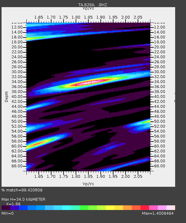
| Estimated Moho Depth: |
34.0 km |
| Estimated Crust Vp/Vs: |
1.86 |
| Assumed Crust Vp: |
6.438 km/s |
| Estimated Crust Vs: |
3.461 km/s |
| Estimated Crust Poisson's Ratio: |
0.30 |
|
| Radial Match: |
88.420906 % |
| Radial Bump: |
400 |
| Transverse Match: |
69.375496 % |
| Transverse Bump: |
400 |
| SOD ConfigId: |
356183 |
| Insert Time: |
2011-08-15 12:38:28.487 +0000 |
| GWidth: |
2.5 |
| Max Bumps: |
400 |
| Tol: |
0.001 |
|

Signal To Noise
| Channel | StoN | STA | LTA |
| TA:B28A: :BHZ:20110311T11:47:57.200029Z | 7.4861927 | 3.2418677E-6 | 4.3304627E-7 |
| TA:B28A: :BHN:20110311T11:47:57.200029Z | 2.1086004 | 8.287424E-7 | 3.930296E-7 |
| TA:B28A: :BHE:20110311T11:47:57.200029Z | 0.8639155 | 7.3270195E-7 | 8.481177E-7 |
| Arrivals |
| Ps | 4.7 SECOND |
| PpPs | 15 SECOND |
| PsPs/PpSs | 19 SECOND |


