You are here: Home > Network List > TA - USArray Transportable Network (new EarthScope stations) Stations List
> Station G05D Wamic, OR, USA > Earthquake Result Viewer
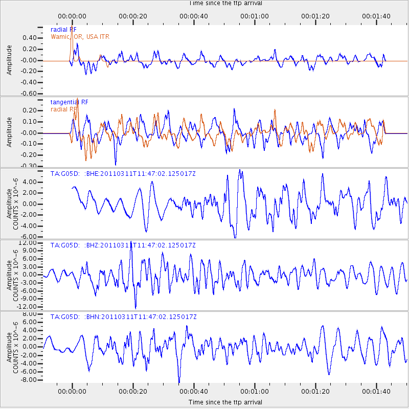
G05D Wamic, OR, USA - Earthquake Result Viewer
*The percent match for this event was below the threshold and hence no stack was calculated.
| Earthquake location: |
Near East Coast Of Honshu, Japan |
| Earthquake latitude/longitude: |
39.2/142.5 |
| Earthquake time(UTC): |
2011/03/11 (070) 11:36:40 GMT |
| Earthquake Depth: |
26 km |
| Earthquake Magnitude: |
6.5 MB, 6.6 MS |
| Earthquake Catalog/Contributor: |
WHDF/NEIC |
|
| Network: |
TA USArray Transportable Network (new EarthScope stations) |
| Station: |
G05D Wamic, OR, USA |
| Lat/Lon: |
45.24 N/121.32 W |
| Elevation: |
592 m |
|
| Distance: |
67.3 deg |
| Az: |
49.596 deg |
| Baz: |
303.173 deg |
| Ray Param: |
$rayparam |
*The percent match for this event was below the threshold and hence was not used in the summary stack. |
|
| Radial Match: |
64.06158 % |
| Radial Bump: |
400 |
| Transverse Match: |
69.455765 % |
| Transverse Bump: |
400 |
| SOD ConfigId: |
356183 |
| Insert Time: |
2011-08-15 12:50:51.381 +0000 |
| GWidth: |
2.5 |
| Max Bumps: |
400 |
| Tol: |
0.001 |
|
Signal To Noise
| Channel | StoN | STA | LTA |
| TA:G05D: :BHZ:20110311T11:47:02.125017Z | 1.9569008 | 2.2921438E-6 | 1.1713132E-6 |
| TA:G05D: :BHN:20110311T11:47:02.125017Z | 0.9145364 | 1.607703E-6 | 1.757943E-6 |
| TA:G05D: :BHE:20110311T11:47:02.125017Z | 0.76543593 | 1.3629782E-6 | 1.7806561E-6 |
| Arrivals |
| Ps | |
| PpPs | |
| PsPs/PpSs | |


