You are here: Home > Network List > TA - USArray Transportable Network (new EarthScope stations) Stations List
> Station U32A Winter Ranch, Mooreland, OK, USA > Earthquake Result Viewer
U32A Winter Ranch, Mooreland, OK, USA - Earthquake Result Viewer
| Earthquake location: |
Near East Coast Of Honshu, Japan |
| Earthquake latitude/longitude: |
39.2/142.5 |
| Earthquake time(UTC): |
2011/03/11 (070) 11:36:40 GMT |
| Earthquake Depth: |
26 km |
| Earthquake Magnitude: |
6.5 MB, 6.6 MS |
| Earthquake Catalog/Contributor: |
WHDF/NEIC |
|
| Network: |
TA USArray Transportable Network (new EarthScope stations) |
| Station: |
U32A Winter Ranch, Mooreland, OK, USA |
| Lat/Lon: |
36.38 N/99.00 W |
| Elevation: |
525 m |
|
| Distance: |
85.8 deg |
| Az: |
45.304 deg |
| Baz: |
316.84 deg |
| Ray Param: |
0.044454187 |
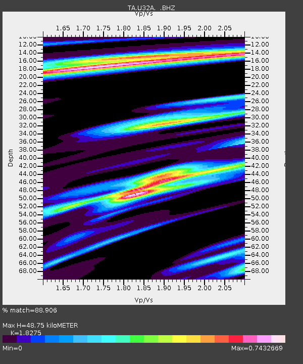
| Estimated Moho Depth: |
48.75 km |
| Estimated Crust Vp/Vs: |
1.83 |
| Assumed Crust Vp: |
6.426 km/s |
| Estimated Crust Vs: |
3.516 km/s |
| Estimated Crust Poisson's Ratio: |
0.29 |
|
| Radial Match: |
88.906 % |
| Radial Bump: |
316 |
| Transverse Match: |
56.080883 % |
| Transverse Bump: |
314 |
| SOD ConfigId: |
356183 |
| Insert Time: |
2011-08-15 12:51:25.430 +0000 |
| GWidth: |
2.5 |
| Max Bumps: |
400 |
| Tol: |
0.001 |
|
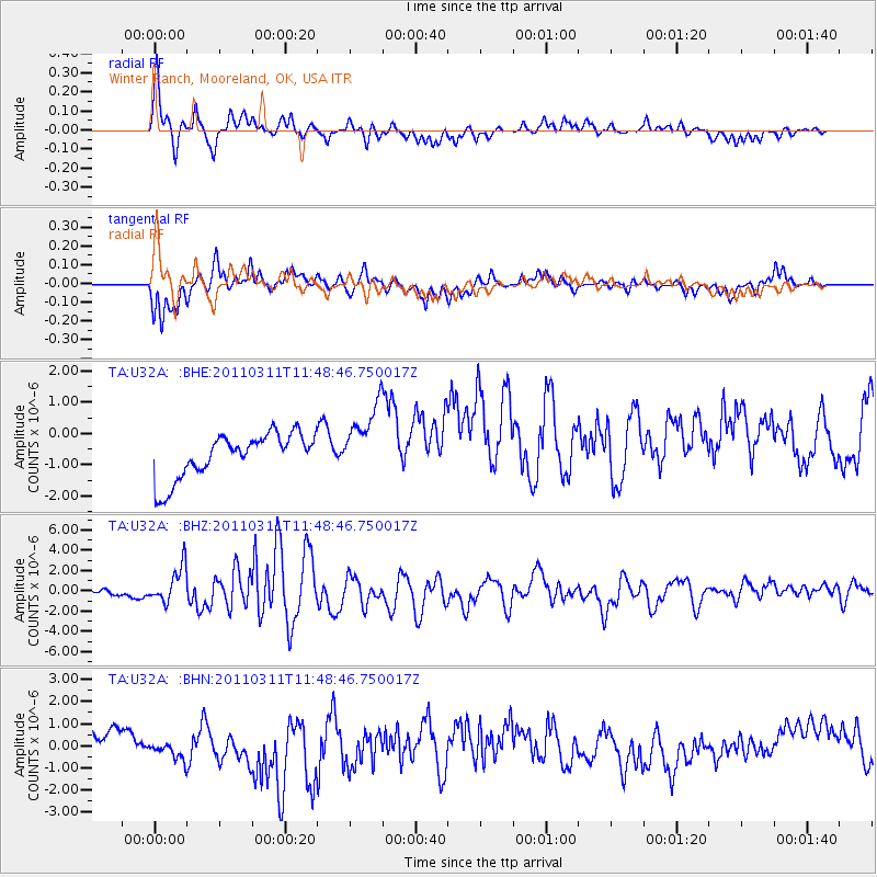
Signal To Noise
| Channel | StoN | STA | LTA |
| TA:U32A: :BHZ:20110311T11:48:46.750017Z | 2.3236642 | 1.9734166E-6 | 8.492693E-7 |
| TA:U32A: :BHN:20110311T11:48:46.750017Z | 0.8698119 | 4.5866733E-7 | 5.273178E-7 |
| TA:U32A: :BHE:20110311T11:48:46.750017Z | 1.609614 | 1.1377202E-6 | 7.0682796E-7 |
| Arrivals |
| Ps | 6.4 SECOND |
| PpPs | 21 SECOND |
| PsPs/PpSs | 27 SECOND |


