You are here: Home > Network List > TA - USArray Transportable Network (new EarthScope stations) Stations List
> Station V34A Guthrie, OK, USA > Earthquake Result Viewer
V34A Guthrie, OK, USA - Earthquake Result Viewer
| Earthquake location: |
Near East Coast Of Honshu, Japan |
| Earthquake latitude/longitude: |
39.2/142.5 |
| Earthquake time(UTC): |
2011/03/11 (070) 11:36:40 GMT |
| Earthquake Depth: |
26 km |
| Earthquake Magnitude: |
6.5 MB, 6.6 MS |
| Earthquake Catalog/Contributor: |
WHDF/NEIC |
|
| Network: |
TA USArray Transportable Network (new EarthScope stations) |
| Station: |
V34A Guthrie, OK, USA |
| Lat/Lon: |
35.83 N/97.52 W |
| Elevation: |
329 m |
|
| Distance: |
87.0 deg |
| Az: |
44.79 deg |
| Baz: |
317.678 deg |
| Ray Param: |
0.043578845 |
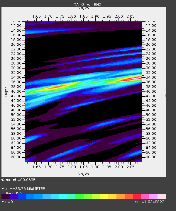
| Estimated Moho Depth: |
33.75 km |
| Estimated Crust Vp/Vs: |
2.10 |
| Assumed Crust Vp: |
6.426 km/s |
| Estimated Crust Vs: |
3.067 km/s |
| Estimated Crust Poisson's Ratio: |
0.35 |
|
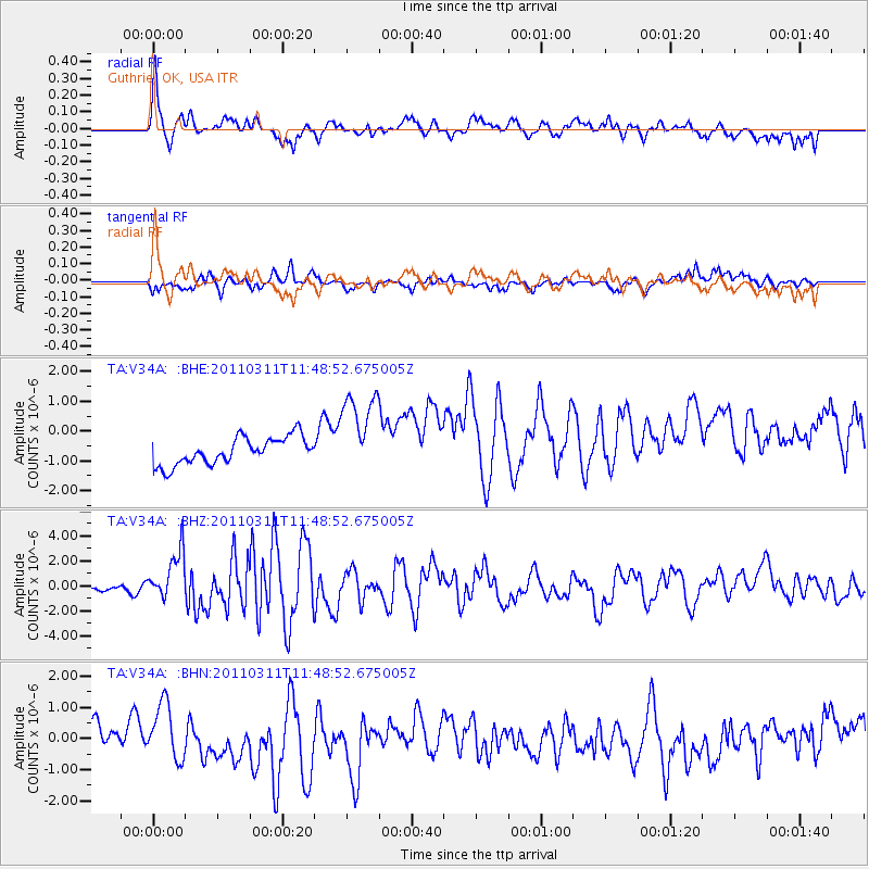
| Radial Match: |
80.0585 % |
| Radial Bump: |
366 |
| Transverse Match: |
60.573105 % |
| Transverse Bump: |
311 |
| SOD ConfigId: |
356183 |
| Insert Time: |
2011-08-15 12:54:03.117 +0000 |
| GWidth: |
2.5 |
| Max Bumps: |
400 |
| Tol: |
0.001 |
|
Signal To Noise
| Channel | StoN | STA | LTA |
| TA:V34A: :BHZ:20110311T11:48:52.675005Z | 6.6249857 | 2.143595E-6 | 3.2356223E-7 |
| TA:V34A: :BHN:20110311T11:48:52.675005Z | 1.9634022 | 8.5618217E-7 | 4.360707E-7 |
| TA:V34A: :BHE:20110311T11:48:52.675005Z | 3.1791618 | 1.4576782E-6 | 4.5851024E-7 |
| Arrivals |
| Ps | 5.9 SECOND |
| PpPs | 16 SECOND |
| PsPs/PpSs | 22 SECOND |


