You are here: Home > Network List > AZ - ANZA Regional Network Stations List
> Station MONP AZ.MONP > Earthquake Result Viewer
MONP AZ.MONP - Earthquake Result Viewer
| Earthquake location: |
South Of Fiji Islands |
| Earthquake latitude/longitude: |
-26.2/-177.7 |
| Earthquake time(UTC): |
2007/07/17 (198) 09:39:27 GMT |
| Earthquake Depth: |
10 km |
| Earthquake Magnitude: |
5.7 MB, 6.0 MS, 6.1 MW, 6.0 MW |
| Earthquake Catalog/Contributor: |
WHDF/NEIC |
|
| Network: |
AZ ANZA Regional Network |
| Station: |
MONP AZ.MONP |
| Lat/Lon: |
32.89 N/116.42 W |
| Elevation: |
1920 m |
|
| Distance: |
82.8 deg |
| Az: |
48.073 deg |
| Baz: |
232.602 deg |
| Ray Param: |
0.046635833 |
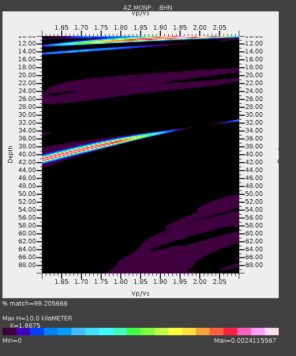
| Estimated Moho Depth: |
10.0 km |
| Estimated Crust Vp/Vs: |
1.99 |
| Assumed Crust Vp: |
6.264 km/s |
| Estimated Crust Vs: |
3.152 km/s |
| Estimated Crust Poisson's Ratio: |
0.33 |
|
| Radial Match: |
99.205666 % |
| Radial Bump: |
26 |
| Transverse Match: |
98.01637 % |
| Transverse Bump: |
56 |
| SOD ConfigId: |
2564 |
| Insert Time: |
2010-02-26 20:00:52.389 +0000 |
| GWidth: |
2.5 |
| Max Bumps: |
400 |
| Tol: |
0.001 |
|
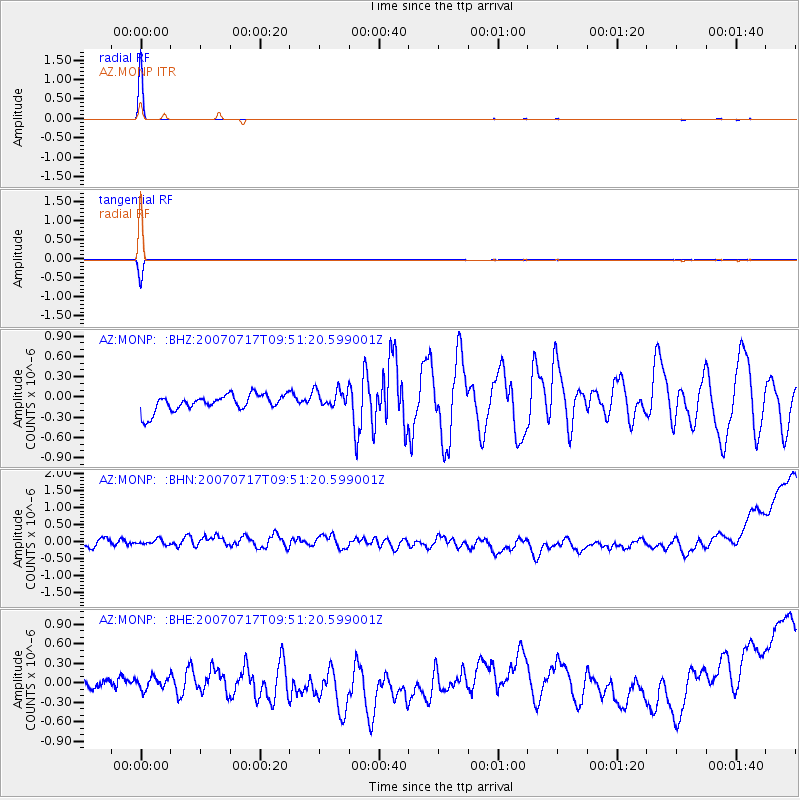
Signal To Noise
| Channel | StoN | STA | LTA |
| AZ:MONP: :BHN:20070717T09:51:20.599001Z | 1.0524998 | 2.6563538E-7 | 2.523852E-7 |
| AZ:MONP: :BHE:20070717T09:51:20.599001Z | 0.9024641 | 9.288221E-8 | 1.0292067E-7 |
| AZ:MONP: :BHZ:20070717T09:51:20.599001Z | 1.179739 | 1.449212E-7 | 1.2284174E-7 |
| Arrivals |
| Ps | 1.6 SECOND |
| PpPs | 4.7 SECOND |
| PsPs/PpSs | 6.3 SECOND |


