You are here: Home > Network List > TA - USArray Transportable Network (new EarthScope stations) Stations List
> Station T34A McClaskey Farms, Geuda Springs, KS, USA > Earthquake Result Viewer
T34A McClaskey Farms, Geuda Springs, KS, USA - Earthquake Result Viewer
| Earthquake location: |
Near East Coast Of Honshu, Japan |
| Earthquake latitude/longitude: |
39.2/142.5 |
| Earthquake time(UTC): |
2011/03/11 (070) 11:36:40 GMT |
| Earthquake Depth: |
26 km |
| Earthquake Magnitude: |
6.5 MB, 6.6 MS |
| Earthquake Catalog/Contributor: |
WHDF/NEIC |
|
| Network: |
TA USArray Transportable Network (new EarthScope stations) |
| Station: |
T34A McClaskey Farms, Geuda Springs, KS, USA |
| Lat/Lon: |
37.02 N/97.19 W |
| Elevation: |
361 m |
|
| Distance: |
86.3 deg |
| Az: |
43.794 deg |
| Baz: |
317.816 deg |
| Ray Param: |
0.04408829 |
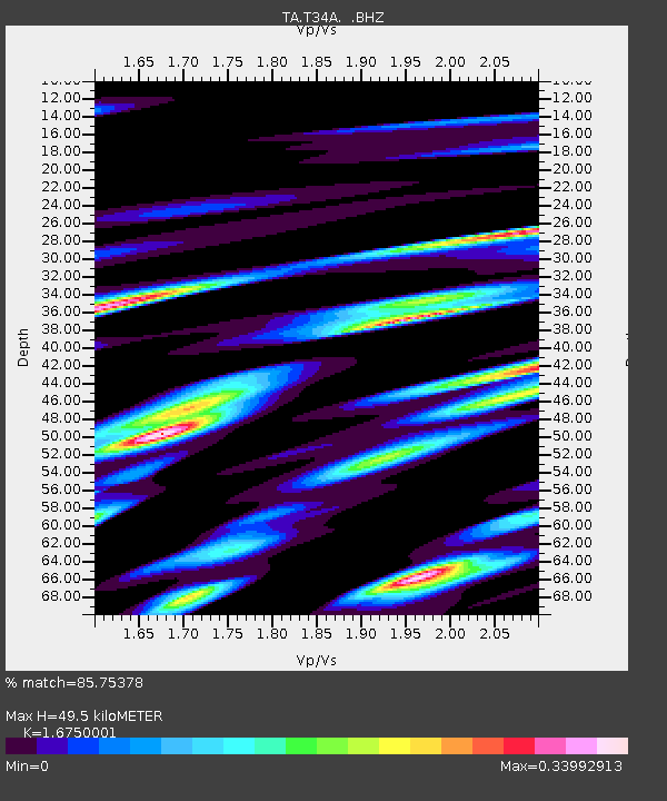
| Estimated Moho Depth: |
49.5 km |
| Estimated Crust Vp/Vs: |
1.68 |
| Assumed Crust Vp: |
6.483 km/s |
| Estimated Crust Vs: |
3.87 km/s |
| Estimated Crust Poisson's Ratio: |
0.22 |
|
| Radial Match: |
85.75378 % |
| Radial Bump: |
310 |
| Transverse Match: |
67.98347 % |
| Transverse Bump: |
361 |
| SOD ConfigId: |
356183 |
| Insert Time: |
2011-08-15 13:09:32.545 +0000 |
| GWidth: |
2.5 |
| Max Bumps: |
400 |
| Tol: |
0.001 |
|

Signal To Noise
| Channel | StoN | STA | LTA |
| TA:T34A: :BHZ:20110311T11:48:49.300005Z | 5.1005225 | 2.2101378E-6 | 4.3331593E-7 |
| TA:T34A: :BHN:20110311T11:48:49.300005Z | 1.793792 | 5.6743517E-7 | 3.1633274E-7 |
| TA:T34A: :BHE:20110311T11:48:49.300005Z | 1.5289828 | 1.1578366E-6 | 7.572594E-7 |
| Arrivals |
| Ps | 5.3 SECOND |
| PpPs | 20 SECOND |
| PsPs/PpSs | 25 SECOND |


