You are here: Home > Network List > AZ - ANZA Regional Network Stations List
> Station MONP AZ.MONP > Earthquake Result Viewer
MONP AZ.MONP - Earthquake Result Viewer
| Earthquake location: |
Vanuatu Islands |
| Earthquake latitude/longitude: |
-15.4/168.6 |
| Earthquake time(UTC): |
2007/07/15 (196) 09:27:34 GMT |
| Earthquake Depth: |
8.0 km |
| Earthquake Magnitude: |
6.0 MB, 5.8 MS, 6.1 MW, 6.0 MW |
| Earthquake Catalog/Contributor: |
WHDF/NEIC |
|
| Network: |
AZ ANZA Regional Network |
| Station: |
MONP AZ.MONP |
| Lat/Lon: |
32.89 N/116.42 W |
| Elevation: |
1920 m |
|
| Distance: |
86.1 deg |
| Az: |
54.536 deg |
| Baz: |
249.039 deg |
| Ray Param: |
0.04428792 |
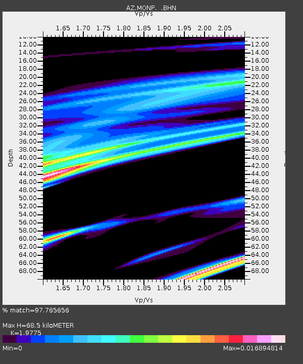
| Estimated Moho Depth: |
68.5 km |
| Estimated Crust Vp/Vs: |
1.98 |
| Assumed Crust Vp: |
6.264 km/s |
| Estimated Crust Vs: |
3.167 km/s |
| Estimated Crust Poisson's Ratio: |
0.33 |
|
| Radial Match: |
97.765656 % |
| Radial Bump: |
72 |
| Transverse Match: |
98.04835 % |
| Transverse Bump: |
78 |
| SOD ConfigId: |
2564 |
| Insert Time: |
2010-02-26 20:00:53.820 +0000 |
| GWidth: |
2.5 |
| Max Bumps: |
400 |
| Tol: |
0.001 |
|

Signal To Noise
| Channel | StoN | STA | LTA |
| AZ:MONP: :BHN:20070715T09:39:44.323018Z | 1.3729303 | 3.8529132E-7 | 2.8063428E-7 |
| AZ:MONP: :BHE:20070715T09:39:44.323018Z | 5.032185 | 7.955132E-7 | 1.5808504E-7 |
| AZ:MONP: :BHZ:20070715T09:39:44.323018Z | 9.401582 | 2.0671316E-6 | 2.1987063E-7 |
| Arrivals |
| Ps | 11 SECOND |
| PpPs | 32 SECOND |
| PsPs/PpSs | 43 SECOND |


