You are here: Home > Network List > AZ - ANZA Regional Network Stations List
> Station MONP AZ.MONP > Earthquake Result Viewer
MONP AZ.MONP - Earthquake Result Viewer

| Earthquake location: |
South Of Fiji Islands |
| Earthquake latitude/longitude: |
-26.3/-178.1 |
| Earthquake time(UTC): |
2007/07/09 (190) 06:50:46 GMT |
| Earthquake Depth: |
10 km |
| Earthquake Magnitude: |
5.5 MB, 5.3 MS, 5.6 MW |
| Earthquake Catalog/Contributor: |
WHDF/NEIC |
|
| Network: |
AZ ANZA Regional Network |
| Station: |
MONP AZ.MONP |
| Lat/Lon: |
32.89 N/116.42 W |
| Elevation: |
1920 m |
|
| Distance: |
83.1 deg |
| Az: |
48.245 deg |
| Baz: |
232.771 deg |
| Ray Param: |
0.046452716 |
| Estimated Moho Depth: |
10.0 km |
| Estimated Crust Vp/Vs: |
1.60 |
| Assumed Crust Vp: |
6.264 km/s |
| Estimated Crust Vs: |
3.915 km/s |
| Estimated Crust Poisson's Ratio: |
0.18 |
|
| Radial Match: |
99.892494 % |
| Radial Bump: |
11 |
| Transverse Match: |
99.87045 % |
| Transverse Bump: |
20 |
| SOD ConfigId: |
2564 |
| Insert Time: |
2010-02-26 20:00:55.355 +0000 |
| GWidth: |
2.5 |
| Max Bumps: |
400 |
| Tol: |
0.001 |
|
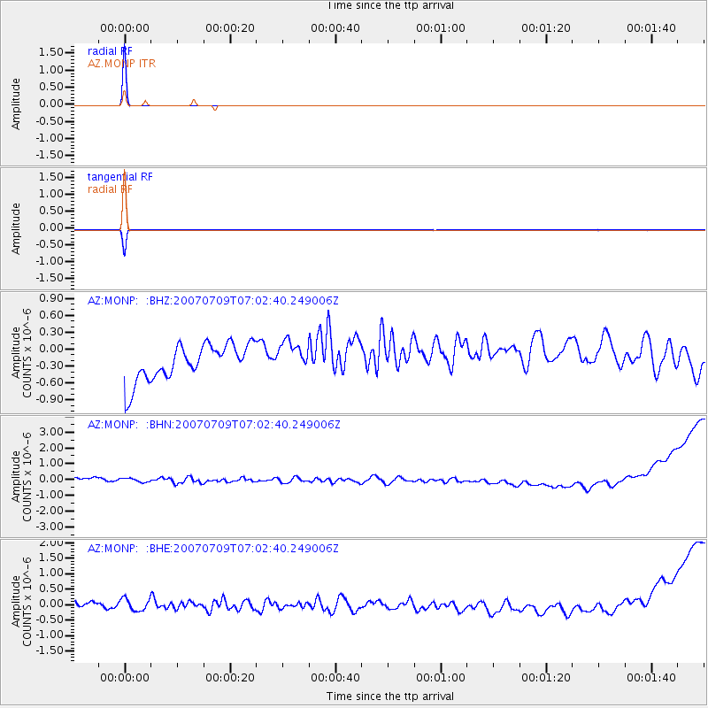
Signal To Noise
| Channel | StoN | STA | LTA |
| AZ:MONP: :BHN:20070709T07:02:40.249006Z | 0.7081497 | 2.7205948E-7 | 3.841836E-7 |
| AZ:MONP: :BHE:20070709T07:02:40.249006Z | 1.2416205 | 2.2327772E-7 | 1.7982768E-7 |
| AZ:MONP: :BHZ:20070709T07:02:40.249006Z | 0.8798705 | 2.813898E-7 | 3.1980818E-7 |
| Arrivals |
| Ps | 1.0 SECOND |
| PpPs | 4.0 SECOND |
| PsPs/PpSs | 5.0 SECOND |


