You are here: Home > Network List > TA - USArray Transportable Network (new EarthScope stations) Stations List
> Station K33A Hardington, NE, USA > Earthquake Result Viewer
K33A Hardington, NE, USA - Earthquake Result Viewer
| Earthquake location: |
Near East Coast Of Honshu, Japan |
| Earthquake latitude/longitude: |
39.2/142.5 |
| Earthquake time(UTC): |
2011/03/11 (070) 11:36:40 GMT |
| Earthquake Depth: |
26 km |
| Earthquake Magnitude: |
6.5 MB, 6.6 MS |
| Earthquake Catalog/Contributor: |
WHDF/NEIC |
|
| Network: |
TA USArray Transportable Network (new EarthScope stations) |
| Station: |
K33A Hardington, NE, USA |
| Lat/Lon: |
42.61 N/97.00 W |
| Elevation: |
507 m |
|
| Distance: |
82.3 deg |
| Az: |
39.916 deg |
| Baz: |
317.552 deg |
| Ray Param: |
0.04693998 |
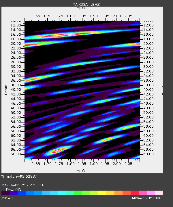
| Estimated Moho Depth: |
66.25 km |
| Estimated Crust Vp/Vs: |
1.75 |
| Assumed Crust Vp: |
6.498 km/s |
| Estimated Crust Vs: |
3.724 km/s |
| Estimated Crust Poisson's Ratio: |
0.26 |
|
| Radial Match: |
92.02837 % |
| Radial Bump: |
400 |
| Transverse Match: |
77.78204 % |
| Transverse Bump: |
400 |
| SOD ConfigId: |
356183 |
| Insert Time: |
2011-08-15 13:19:39.247 +0000 |
| GWidth: |
2.5 |
| Max Bumps: |
400 |
| Tol: |
0.001 |
|
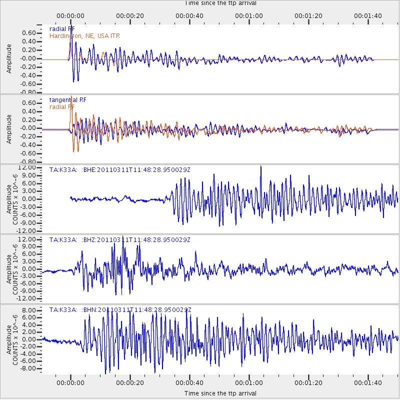
Signal To Noise
| Channel | StoN | STA | LTA |
| TA:K33A: :BHZ:20110311T11:48:28.950029Z | 3.3117867 | 2.9163996E-6 | 8.806122E-7 |
| TA:K33A: :BHN:20110311T11:48:28.950029Z | 2.1175117 | 1.3902558E-6 | 6.565516E-7 |
| TA:K33A: :BHE:20110311T11:48:28.950029Z | 3.095191 | 1.4955556E-6 | 4.831869E-7 |
| Arrivals |
| Ps | 7.8 SECOND |
| PpPs | 27 SECOND |
| PsPs/PpSs | 35 SECOND |


