You are here: Home > Network List > TA - USArray Transportable Network (new EarthScope stations) Stations List
> Station J31A Geddes, SD, USA > Earthquake Result Viewer
J31A Geddes, SD, USA - Earthquake Result Viewer
| Earthquake location: |
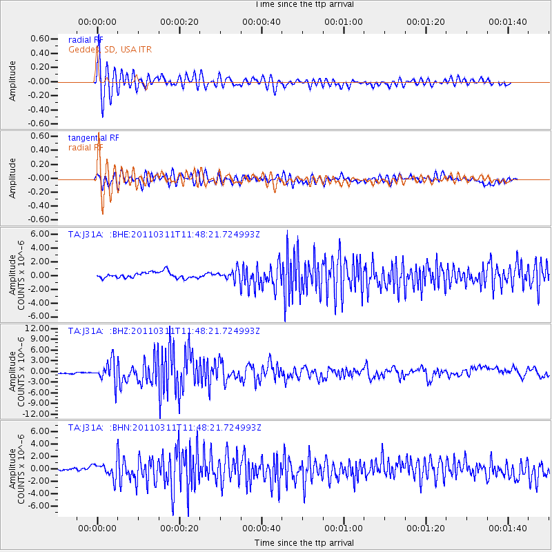
Near East Coast Of Honshu, Japan |
| Earthquake latitude/longitude: |
39.2/142.5 |
| Earthquake time(UTC): |
2011/03/11 (070) 11:36:40 GMT |
| Earthquake Depth: |
26 km |
| Earthquake Magnitude: |
6.5 MB, 6.6 MS |
| Earthquake Catalog/Contributor: |
WHDF/NEIC |
|
| Network: |
TA USArray Transportable Network (new EarthScope stations) |
| Station: |
J31A Geddes, SD, USA |
| Lat/Lon: |
43.29 N/98.74 W |
| Elevation: |
491 m |
|
| Distance: |
80.9 deg |
| Az: |
40.386 deg |
| Baz: |
316.44 deg |
| Ray Param: |
0.047900952 |
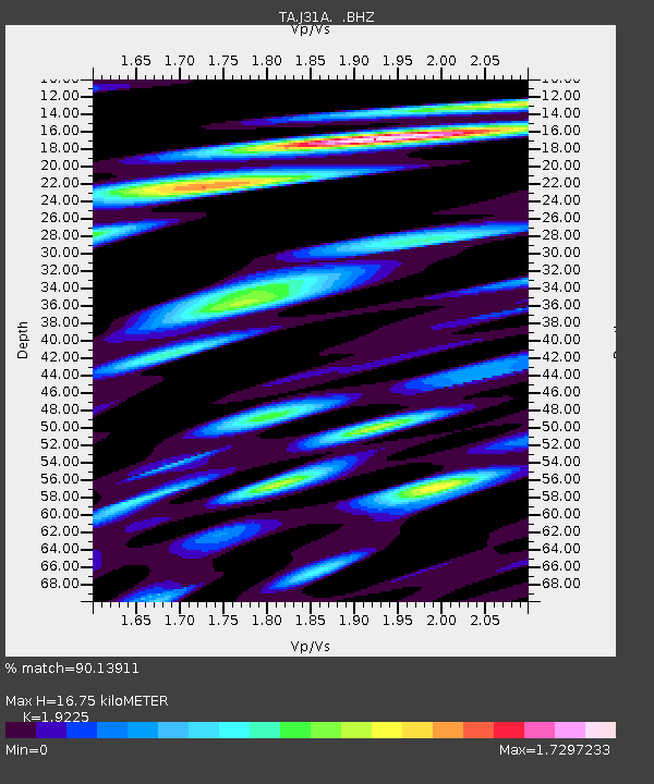
| Estimated Moho Depth: |
16.75 km |
| Estimated Crust Vp/Vs: |
1.92 |
| Assumed Crust Vp: |
6.53 km/s |
| Estimated Crust Vs: |
3.397 km/s |
| Estimated Crust Poisson's Ratio: |
0.31 |
|
| Radial Match: |
90.13911 % |
| Radial Bump: |
400 |
| Transverse Match: |
78.37349 % |
| Transverse Bump: |
400 |
| SOD ConfigId: |
356183 |
| Insert Time: |
2011-08-15 13:22:26.848 +0000 |
| GWidth: |
2.5 |
| Max Bumps: |
400 |
| Tol: |
0.001 |
|
Signal To Noise
| Channel | StoN | STA | LTA |
| TA:J31A: :BHZ:20110311T11:48:21.724993Z | 6.6885595 | 3.0126455E-6 | 4.504177E-7 |
| TA:J31A: :BHN:20110311T11:48:21.724993Z | 2.858606 | 1.2614292E-6 | 4.4127427E-7 |
| TA:J31A: :BHE:20110311T11:48:21.724993Z | 1.6735787 | 7.307533E-7 | 4.3664113E-7 |
| Arrivals |
| Ps | 2.4 SECOND |
| PpPs | 7.3 SECOND |
| PsPs/PpSs | 9.7 SECOND |


