You are here: Home > Network List > AZ - ANZA Regional Network Stations List
> Station MONP AZ.MONP > Earthquake Result Viewer
MONP AZ.MONP - Earthquake Result Viewer

| Earthquake location: |
Solomon Islands |
| Earthquake latitude/longitude: |
-8.5/157.0 |
| Earthquake time(UTC): |
2007/04/01 (091) 20:39:56 GMT |
| Earthquake Depth: |
10 km |
| Earthquake Magnitude: |
6.8 MB, 7.9 MS, 8.1 MW, 7.7 ME |
| Earthquake Catalog/Contributor: |
WHDF/NEIC |
|
| Network: |
AZ ANZA Regional Network |
| Station: |
MONP AZ.MONP |
| Lat/Lon: |
32.89 N/116.42 W |
| Elevation: |
1920 m |
|
| Distance: |
91.6 deg |
| Az: |
57.156 deg |
| Baz: |
261.062 deg |
| Ray Param: |
0.041578688 |
| Estimated Moho Depth: |
30.5 km |
| Estimated Crust Vp/Vs: |
1.76 |
| Assumed Crust Vp: |
6.264 km/s |
| Estimated Crust Vs: |
3.564 km/s |
| Estimated Crust Poisson's Ratio: |
0.26 |
|
| Radial Match: |
95.9647 % |
| Radial Bump: |
400 |
| Transverse Match: |
87.83532 % |
| Transverse Bump: |
400 |
| SOD ConfigId: |
2564 |
| Insert Time: |
2010-02-26 20:01:00.884 +0000 |
| GWidth: |
2.5 |
| Max Bumps: |
400 |
| Tol: |
0.001 |
|
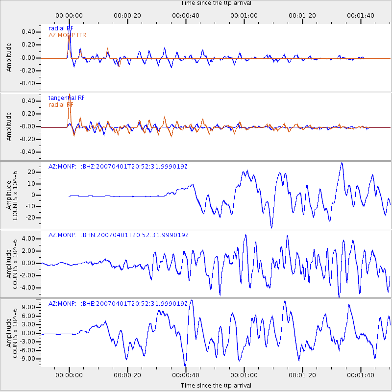
Signal To Noise
| Channel | StoN | STA | LTA |
| AZ:MONP: :BHN:20070401T20:52:31.999019Z | 0.5473062 | 1.497571E-7 | 2.736258E-7 |
| AZ:MONP: :BHE:20070401T20:52:31.999019Z | 2.0424533 | 5.205238E-7 | 2.5485227E-7 |
| AZ:MONP: :BHZ:20070401T20:52:31.999019Z | 5.7132063 | 1.2124948E-6 | 2.1222668E-7 |
| Arrivals |
| Ps | 3.8 SECOND |
| PpPs | 13 SECOND |
| PsPs/PpSs | 17 SECOND |


