You are here: Home > Network List > TA - USArray Transportable Network (new EarthScope stations) Stations List
> Station M37A Trindle Farm, Earlham, IA, USA > Earthquake Result Viewer
M37A Trindle Farm, Earlham, IA, USA - Earthquake Result Viewer
| Earthquake location: |
Near East Coast Of Honshu, Japan |
| Earthquake latitude/longitude: |
39.2/142.5 |
| Earthquake time(UTC): |
2011/03/11 (070) 11:36:40 GMT |
| Earthquake Depth: |
26 km |
| Earthquake Magnitude: |
6.5 MB, 6.6 MS |
| Earthquake Catalog/Contributor: |
WHDF/NEIC |
|
| Network: |
TA USArray Transportable Network (new EarthScope stations) |
| Station: |
M37A Trindle Farm, Earlham, IA, USA |
| Lat/Lon: |
41.40 N/94.06 W |
| Elevation: |
325 m |
|
| Distance: |
84.7 deg |
| Az: |
39.064 deg |
| Baz: |
319.418 deg |
| Ray Param: |
0.04528474 |
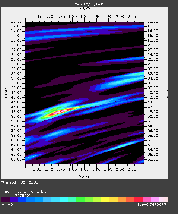
| Estimated Moho Depth: |
47.75 km |
| Estimated Crust Vp/Vs: |
1.75 |
| Assumed Crust Vp: |
6.498 km/s |
| Estimated Crust Vs: |
3.718 km/s |
| Estimated Crust Poisson's Ratio: |
0.26 |
|
| Radial Match: |
80.70181 % |
| Radial Bump: |
342 |
| Transverse Match: |
59.48934 % |
| Transverse Bump: |
400 |
| SOD ConfigId: |
356183 |
| Insert Time: |
2011-08-15 13:41:05.915 +0000 |
| GWidth: |
2.5 |
| Max Bumps: |
400 |
| Tol: |
0.001 |
|
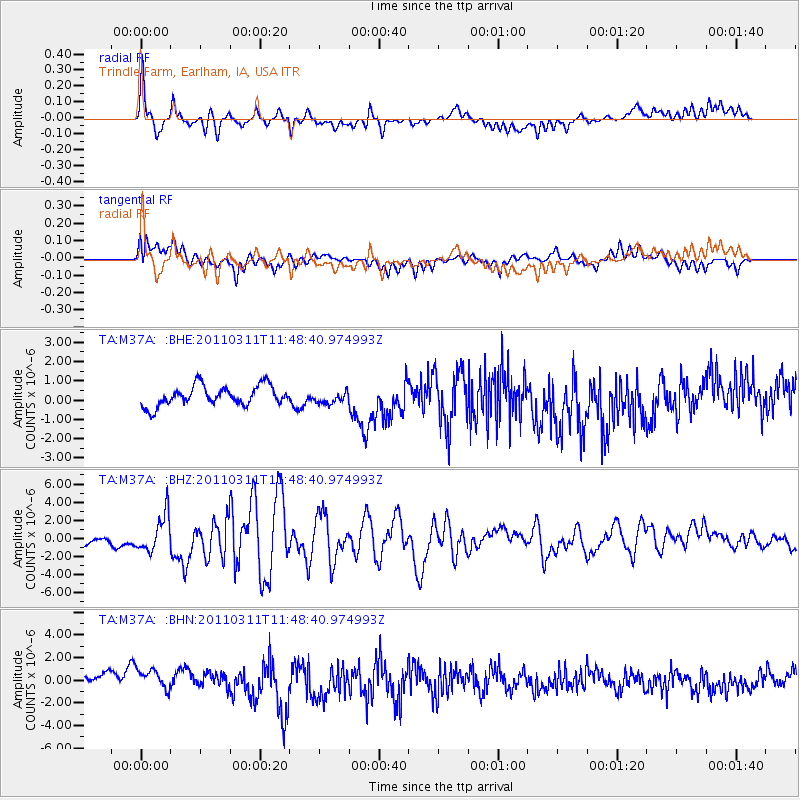
Signal To Noise
| Channel | StoN | STA | LTA |
| TA:M37A: :BHZ:20110311T11:48:40.974993Z | 4.2418184 | 1.9721838E-6 | 4.6493827E-7 |
| TA:M37A: :BHN:20110311T11:48:40.974993Z | 1.1587439 | 1.2605626E-6 | 1.0878699E-6 |
| TA:M37A: :BHE:20110311T11:48:40.974993Z | 0.6078853 | 3.1432344E-7 | 5.170769E-7 |
| Arrivals |
| Ps | 5.6 SECOND |
| PpPs | 20 SECOND |
| PsPs/PpSs | 25 SECOND |


