You are here: Home > Network List > TA - USArray Transportable Network (new EarthScope stations) Stations List
> Station M54A Oil Creek State Park, Oil City, PA, USA > Earthquake Result Viewer
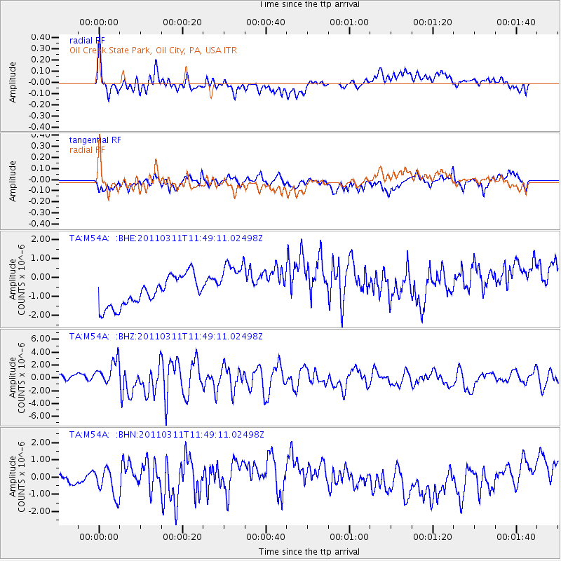
M54A Oil Creek State Park, Oil City, PA, USA - Earthquake Result Viewer
*The percent match for this event was below the threshold and hence no stack was calculated.
| Earthquake location: |
Near East Coast Of Honshu, Japan |
| Earthquake latitude/longitude: |
39.2/142.5 |
| Earthquake time(UTC): |
2011/03/11 (070) 11:36:40 GMT |
| Earthquake Depth: |
26 km |
| Earthquake Magnitude: |
6.5 MB, 6.6 MS |
| Earthquake Catalog/Contributor: |
WHDF/NEIC |
|
| Network: |
TA USArray Transportable Network (new EarthScope stations) |
| Station: |
M54A Oil Creek State Park, Oil City, PA, USA |
| Lat/Lon: |
41.51 N/79.66 W |
| Elevation: |
488 m |
|
| Distance: |
91.0 deg |
| Az: |
30.257 deg |
| Baz: |
328.602 deg |
| Ray Param: |
$rayparam |
*The percent match for this event was below the threshold and hence was not used in the summary stack. |
|
| Radial Match: |
61.03208 % |
| Radial Bump: |
400 |
| Transverse Match: |
37.44659 % |
| Transverse Bump: |
355 |
| SOD ConfigId: |
356183 |
| Insert Time: |
2011-08-15 13:41:06.768 +0000 |
| GWidth: |
2.5 |
| Max Bumps: |
400 |
| Tol: |
0.001 |
|
Signal To Noise
| Channel | StoN | STA | LTA |
| TA:M54A: :BHZ:20110311T11:49:11.02498Z | 3.8735228 | 2.1681687E-6 | 5.597408E-7 |
| TA:M54A: :BHN:20110311T11:49:11.02498Z | 0.88405097 | 8.9726274E-7 | 1.0149446E-6 |
| TA:M54A: :BHE:20110311T11:49:11.02498Z | 1.7043774 | 1.2958395E-6 | 7.6030074E-7 |
| Arrivals |
| Ps | |
| PpPs | |
| PsPs/PpSs | |


