You are here: Home > Network List > TA - USArray Transportable Network (new EarthScope stations) Stations List
> Station P39A Salisbury, MO, USA > Earthquake Result Viewer
P39A Salisbury, MO, USA - Earthquake Result Viewer
| Earthquake location: |
Near East Coast Of Honshu, Japan |
| Earthquake latitude/longitude: |
39.2/142.5 |
| Earthquake time(UTC): |
2011/03/11 (070) 11:36:40 GMT |
| Earthquake Depth: |
26 km |
| Earthquake Magnitude: |
6.5 MB, 6.6 MS |
| Earthquake Catalog/Contributor: |
WHDF/NEIC |
|
| Network: |
TA USArray Transportable Network (new EarthScope stations) |
| Station: |
P39A Salisbury, MO, USA |
| Lat/Lon: |
39.49 N/92.75 W |
| Elevation: |
232 m |
|
| Distance: |
86.8 deg |
| Az: |
39.538 deg |
| Baz: |
320.296 deg |
| Ray Param: |
0.043776296 |
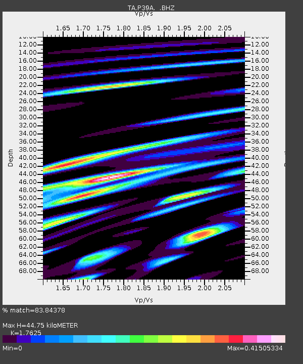
| Estimated Moho Depth: |
44.75 km |
| Estimated Crust Vp/Vs: |
1.76 |
| Assumed Crust Vp: |
6.498 km/s |
| Estimated Crust Vs: |
3.687 km/s |
| Estimated Crust Poisson's Ratio: |
0.26 |
|
| Radial Match: |
83.84378 % |
| Radial Bump: |
400 |
| Transverse Match: |
82.678 % |
| Transverse Bump: |
400 |
| SOD ConfigId: |
356183 |
| Insert Time: |
2011-08-15 13:48:30.243 +0000 |
| GWidth: |
2.5 |
| Max Bumps: |
400 |
| Tol: |
0.001 |
|
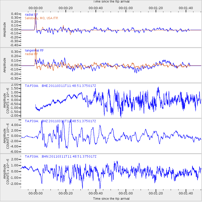
Signal To Noise
| Channel | StoN | STA | LTA |
| TA:P39A: :BHZ:20110311T11:48:51.375017Z | 8.312986 | 2.064423E-6 | 2.483371E-7 |
| TA:P39A: :BHN:20110311T11:48:51.375017Z | 0.832045 | 6.644606E-7 | 7.9858734E-7 |
| TA:P39A: :BHE:20110311T11:48:51.375017Z | 1.5963147 | 8.4887813E-7 | 5.317737E-7 |
| Arrivals |
| Ps | 5.4 SECOND |
| PpPs | 19 SECOND |
| PsPs/PpSs | 24 SECOND |


