You are here: Home > Network List > US - United States National Seismic Network Stations List
> Station ERPA Erie, Pennsylvania, USA > Earthquake Result Viewer
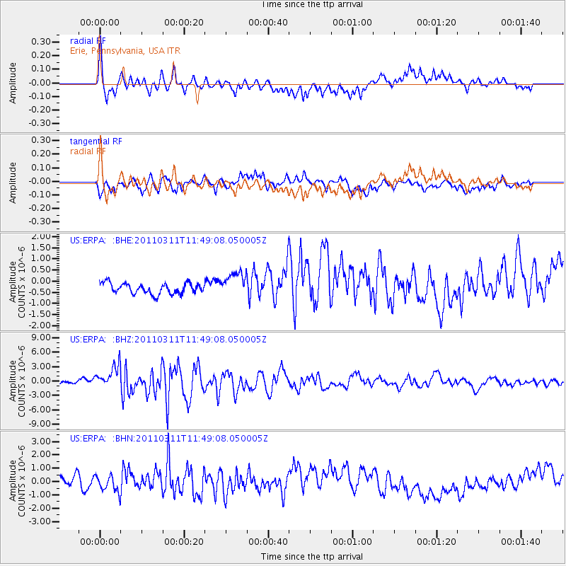
ERPA Erie, Pennsylvania, USA - Earthquake Result Viewer
*The percent match for this event was below the threshold and hence no stack was calculated.
| Earthquake location: |
Near East Coast Of Honshu, Japan |
| Earthquake latitude/longitude: |
39.2/142.5 |
| Earthquake time(UTC): |
2011/03/11 (070) 11:36:40 GMT |
| Earthquake Depth: |
26 km |
| Earthquake Magnitude: |
6.5 MB, 6.6 MS |
| Earthquake Catalog/Contributor: |
WHDF/NEIC |
|
| Network: |
US United States National Seismic Network |
| Station: |
ERPA Erie, Pennsylvania, USA |
| Lat/Lon: |
42.12 N/79.99 W |
| Elevation: |
306 m |
|
| Distance: |
90.3 deg |
| Az: |
30.145 deg |
| Baz: |
328.388 deg |
| Ray Param: |
$rayparam |
*The percent match for this event was below the threshold and hence was not used in the summary stack. |
|
| Radial Match: |
60.75756 % |
| Radial Bump: |
349 |
| Transverse Match: |
55.447445 % |
| Transverse Bump: |
394 |
| SOD ConfigId: |
356183 |
| Insert Time: |
2011-08-15 14:08:56.956 +0000 |
| GWidth: |
2.5 |
| Max Bumps: |
400 |
| Tol: |
0.001 |
|
Signal To Noise
| Channel | StoN | STA | LTA |
| US:ERPA: :BHZ:20110311T11:49:08.050005Z | 5.4861174 | 2.7783778E-6 | 5.064379E-7 |
| US:ERPA: :BHN:20110311T11:49:08.050005Z | 0.7934608 | 7.953796E-7 | 1.0024183E-6 |
| US:ERPA: :BHE:20110311T11:49:08.050005Z | 2.400389 | 5.736773E-7 | 2.3899347E-7 |
| Arrivals |
| Ps | |
| PpPs | |
| PsPs/PpSs | |


