You are here: Home > Network List > AZ - ANZA Regional Network Stations List
> Station MONP AZ.MONP > Earthquake Result Viewer
MONP AZ.MONP - Earthquake Result Viewer
| Earthquake location: |
Tonga Islands |
| Earthquake latitude/longitude: |
-21.8/-175.1 |
| Earthquake time(UTC): |
2006/09/03 (246) 04:26:29 GMT |
| Earthquake Depth: |
37 km |
| Earthquake Magnitude: |
5.3 MB, 5.2 MS, 5.6 MW, 5.6 MW |
| Earthquake Catalog/Contributor: |
WHDF/NEIC |
|
| Network: |
AZ ANZA Regional Network |
| Station: |
MONP AZ.MONP |
| Lat/Lon: |
32.89 N/116.42 W |
| Elevation: |
1920 m |
|
| Distance: |
78.1 deg |
| Az: |
47.298 deg |
| Baz: |
234.267 deg |
| Ray Param: |
0.049823117 |
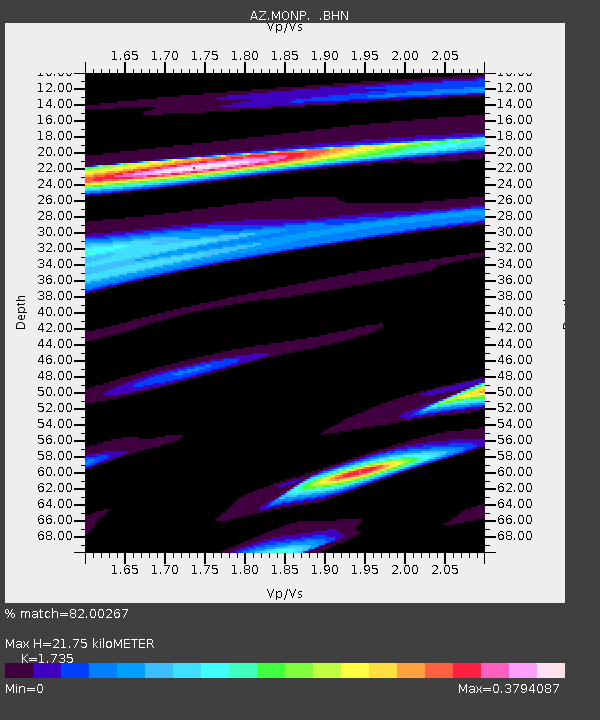
| Estimated Moho Depth: |
21.75 km |
| Estimated Crust Vp/Vs: |
1.74 |
| Assumed Crust Vp: |
6.264 km/s |
| Estimated Crust Vs: |
3.61 km/s |
| Estimated Crust Poisson's Ratio: |
0.25 |
|
| Radial Match: |
82.00267 % |
| Radial Bump: |
223 |
| Transverse Match: |
74.39588 % |
| Transverse Bump: |
235 |
| SOD ConfigId: |
2665 |
| Insert Time: |
2010-02-26 20:01:20.551 +0000 |
| GWidth: |
2.5 |
| Max Bumps: |
400 |
| Tol: |
0.001 |
|
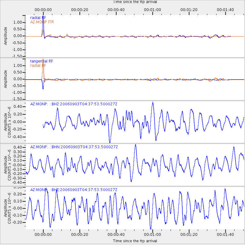
Signal To Noise
| Channel | StoN | STA | LTA |
| AZ:MONP: :BHN:20060903T04:37:53.500027Z | 0.83649015 | 1.1442731E-7 | 1.3679457E-7 |
| AZ:MONP: :BHE:20060903T04:37:53.500027Z | 1.8592634 | 1.9068395E-7 | 1.0255887E-7 |
| AZ:MONP: :BHZ:20060903T04:37:53.500027Z | 0.7097829 | 8.935432E-8 | 1.2588966E-7 |
| Arrivals |
| Ps | 2.6 SECOND |
| PpPs | 9.2 SECOND |
| PsPs/PpSs | 12 SECOND |


