You are here: Home > Network List > AZ - ANZA Regional Network Stations List
> Station MONP AZ.MONP > Earthquake Result Viewer
MONP AZ.MONP - Earthquake Result Viewer
| Earthquake location: |
Fiji Islands Region |
| Earthquake latitude/longitude: |
-17.9/-178.6 |
| Earthquake time(UTC): |
2006/07/23 (204) 20:50:51 GMT |
| Earthquake Depth: |
587 km |
| Earthquake Magnitude: |
5.6 MB, 5.7 MW, 5.7 MW |
| Earthquake Catalog/Contributor: |
WHDF/NEIC |
|
| Network: |
AZ ANZA Regional Network |
| Station: |
MONP AZ.MONP |
| Lat/Lon: |
32.89 N/116.42 W |
| Elevation: |
1920 m |
|
| Distance: |
78.0 deg |
| Az: |
49.543 deg |
| Baz: |
239.432 deg |
| Ray Param: |
0.04811413 |
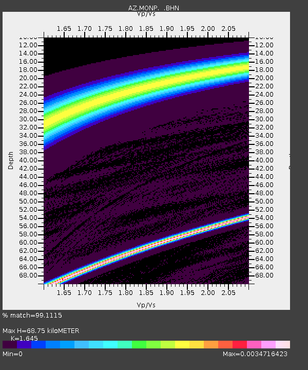
| Estimated Moho Depth: |
68.75 km |
| Estimated Crust Vp/Vs: |
1.64 |
| Assumed Crust Vp: |
6.264 km/s |
| Estimated Crust Vs: |
3.808 km/s |
| Estimated Crust Poisson's Ratio: |
0.21 |
|
| Radial Match: |
99.1115 % |
| Radial Bump: |
44 |
| Transverse Match: |
98.45631 % |
| Transverse Bump: |
65 |
| SOD ConfigId: |
2665 |
| Insert Time: |
2010-02-26 20:01:24.031 +0000 |
| GWidth: |
2.5 |
| Max Bumps: |
400 |
| Tol: |
0.001 |
|
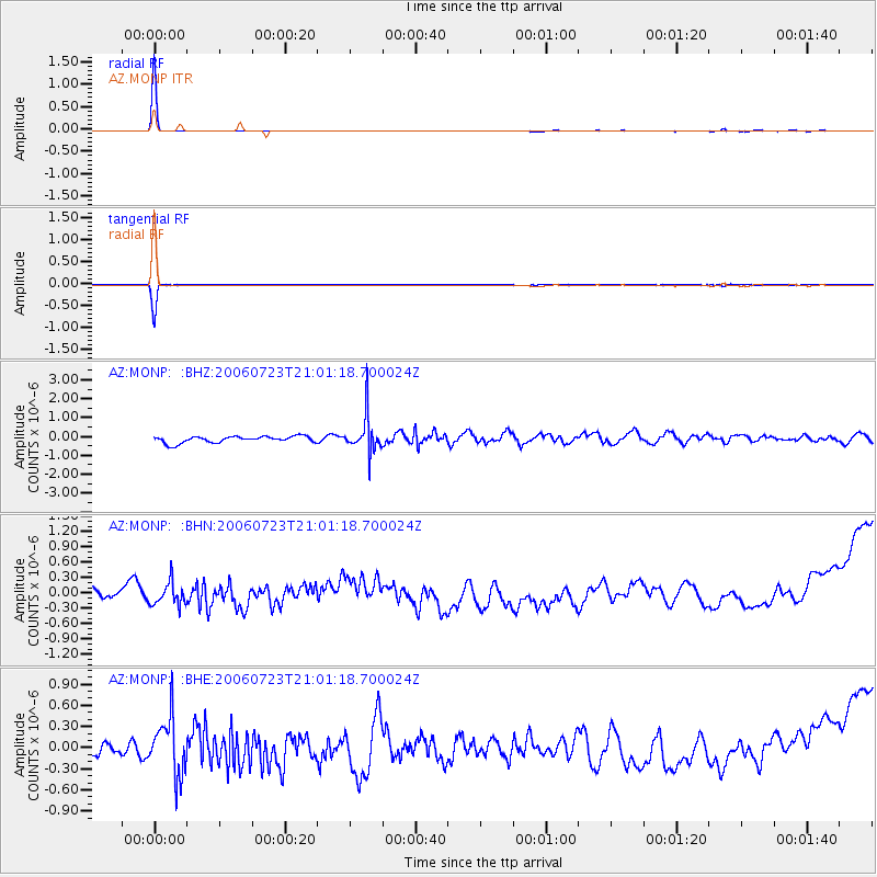
Signal To Noise
| Channel | StoN | STA | LTA |
| AZ:MONP: :BHN:20060723T21:01:18.700024Z | 1.0955255 | 2.3555242E-7 | 2.1501317E-7 |
| AZ:MONP: :BHE:20060723T21:01:18.700024Z | 2.2566347 | 4.0262518E-7 | 1.7841842E-7 |
| AZ:MONP: :BHZ:20060723T21:01:18.700024Z | 5.66224 | 9.787259E-7 | 1.7285136E-7 |
| Arrivals |
| Ps | 7.3 SECOND |
| PpPs | 28 SECOND |
| PsPs/PpSs | 36 SECOND |


