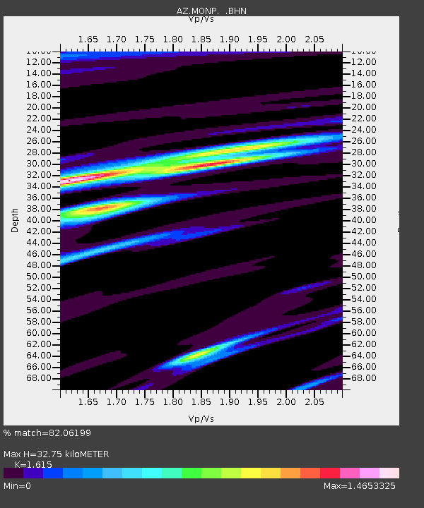
MONP AZ.MONP - Earthquake Result Viewer
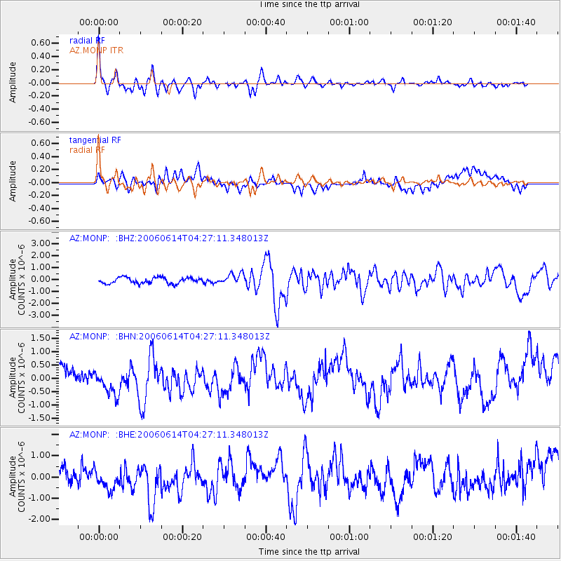
Earthquake location: Rat Islands, Aleutian Islands
Earthquake latitude/longitude: 51.8/177.1
Earthquake time(UTC): 2006/06/14 (165) 04:18:42 GMT
Earthquake Depth: 14 km
Earthquake Magnitude: 5.9 MB, 6.4 MS, 6.4 MW, 6.4 MW
Earthquake Catalog/Contributor: WHDF/NEIC
Network: AZ ANZA Regional Network
Station: MONP AZ.MONP
Lat/Lon: 32.89 N/116.42 W
Elevation: 1920 m
Distance: 50.8 deg
Az: 84.584 deg
Baz: 312.646 deg
Ray Param: 0.06779976
Estimated Moho Depth: 32.75 km
Estimated Crust Vp/Vs: 1.62
Assumed Crust Vp: 6.264 km/s
Estimated Crust Vs: 3.878 km/s
Estimated Crust Poisson's Ratio: 0.19
Radial Match: 82.06199 %
Radial Bump: 400
Transverse Match: 62.342434 %
Transverse Bump: 400
SOD ConfigId: 5745
Insert Time: 2010-02-26 20:01:29.317 +0000
GWidth: 2.5
Max Bumps: 400
Tol: 0.001

Signal To Noise

ChannelStoNSTALTA
AZ:MONP: :BHN:20060614T04:27:11.348013Z1.40518935.7024204E-74.058116E-7
AZ:MONP: :BHE:20060614T04:27:11.348013Z1.49278576.09133E-74.0805122E-7
AZ:MONP: :BHZ:20060614T04:27:11.348013Z1.87893844.6788176E-72.4901388E-7
Arrivals
Ps3.4 SECOND
PpPs13 SECOND
PsPs/PpSs16 SECOND