You are here: Home > Network List > TA - USArray Transportable Network (new EarthScope stations) Stations List
> Station R56A Bull Pasture Mountain, McDowell, VA, USA > Earthquake Result Viewer
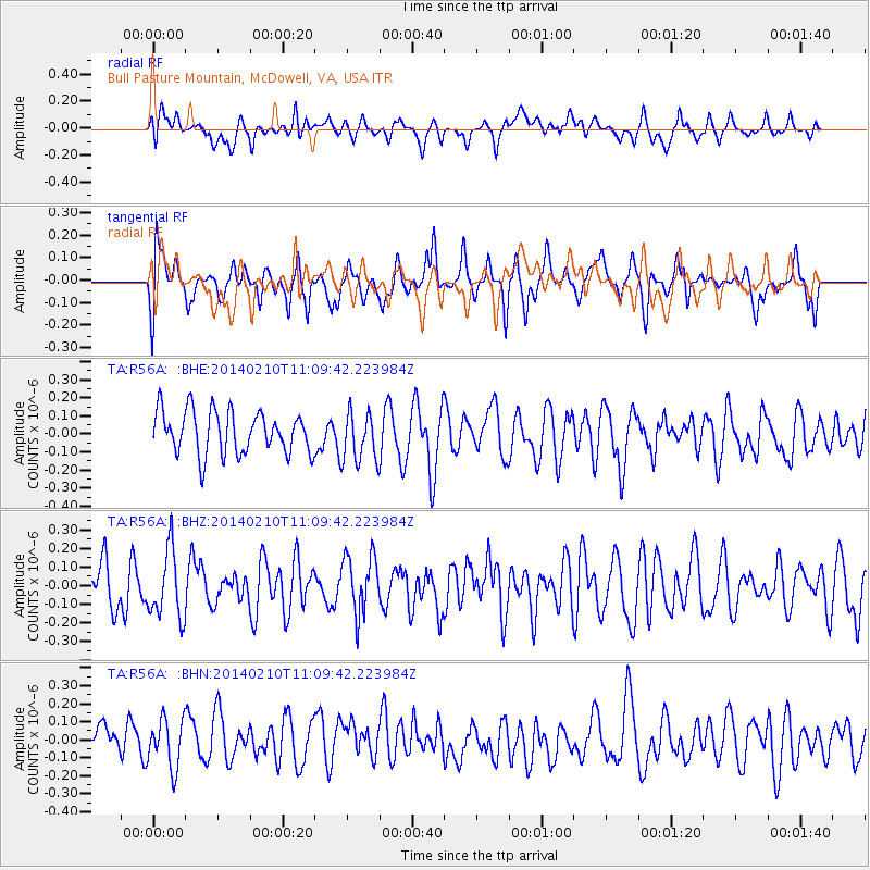
R56A Bull Pasture Mountain, McDowell, VA, USA - Earthquake Result Viewer
*The percent match for this event was below the threshold and hence no stack was calculated.
| Earthquake location: |
Northern Chile |
| Earthquake latitude/longitude: |
-22.3/-68.7 |
| Earthquake time(UTC): |
2014/02/10 (041) 11:00:09 GMT |
| Earthquake Depth: |
107 km |
| Earthquake Magnitude: |
5.2 MW |
| Earthquake Catalog/Contributor: |
ISC/ISC |
|
| Network: |
TA USArray Transportable Network (new EarthScope stations) |
| Station: |
R56A Bull Pasture Mountain, McDowell, VA, USA |
| Lat/Lon: |
38.41 N/79.40 W |
| Elevation: |
902 m |
|
| Distance: |
61.2 deg |
| Az: |
350.378 deg |
| Baz: |
168.633 deg |
| Ray Param: |
$rayparam |
*The percent match for this event was below the threshold and hence was not used in the summary stack. |
|
| Radial Match: |
42.159473 % |
| Radial Bump: |
400 |
| Transverse Match: |
54.21296 % |
| Transverse Bump: |
400 |
| SOD ConfigId: |
3390531 |
| Insert Time: |
2019-04-10 07:10:43.022 +0000 |
| GWidth: |
2.5 |
| Max Bumps: |
400 |
| Tol: |
0.001 |
|
Signal To Noise
| Channel | StoN | STA | LTA |
| TA:R56A: :BHZ:20140210T11:09:42.223984Z | 1.6666356 | 1.8365134E-7 | 1.1019286E-7 |
| TA:R56A: :BHN:20140210T11:09:42.223984Z | 1.1952385 | 1.3584594E-7 | 1.13655915E-7 |
| TA:R56A: :BHE:20140210T11:09:42.223984Z | 1.182049 | 1.3966388E-7 | 1.1815405E-7 |
| Arrivals |
| Ps | |
| PpPs | |
| PsPs/PpSs | |


