You are here: Home > Network List > AZ - ANZA Regional Network Stations List
> Station MONP AZ.MONP > Earthquake Result Viewer
MONP AZ.MONP - Earthquake Result Viewer
| Earthquake location: |
New Ireland Region, P.N.G. |
| Earthquake latitude/longitude: |
-4.8/153.2 |
| Earthquake time(UTC): |
2000/11/16 (321) 07:45:32 GMT |
| Earthquake Depth: |
33 km |
| Earthquake Magnitude: |
6.5 MB, 7.2 MS |
| Earthquake Catalog/Contributor: |
WHDF/NEIC |
|
| Network: |
AZ ANZA Regional Network |
| Station: |
MONP AZ.MONP |
| Lat/Lon: |
32.89 N/116.42 W |
| Elevation: |
1920 m |
|
| Distance: |
92.9 deg |
| Az: |
57.394 deg |
| Baz: |
266.152 deg |
| Ray Param: |
0.041359257 |
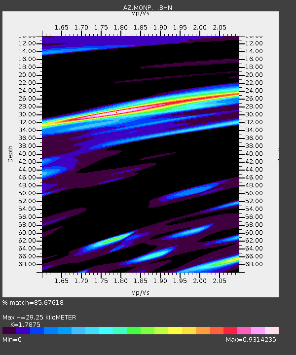
| Estimated Moho Depth: |
29.25 km |
| Estimated Crust Vp/Vs: |
1.79 |
| Assumed Crust Vp: |
6.264 km/s |
| Estimated Crust Vs: |
3.504 km/s |
| Estimated Crust Poisson's Ratio: |
0.27 |
|
| Radial Match: |
85.67618 % |
| Radial Bump: |
346 |
| Transverse Match: |
81.18314 % |
| Transverse Bump: |
293 |
| SOD ConfigId: |
3744 |
| Insert Time: |
2010-02-26 20:01:42.711 +0000 |
| GWidth: |
2.5 |
| Max Bumps: |
400 |
| Tol: |
0.001 |
|
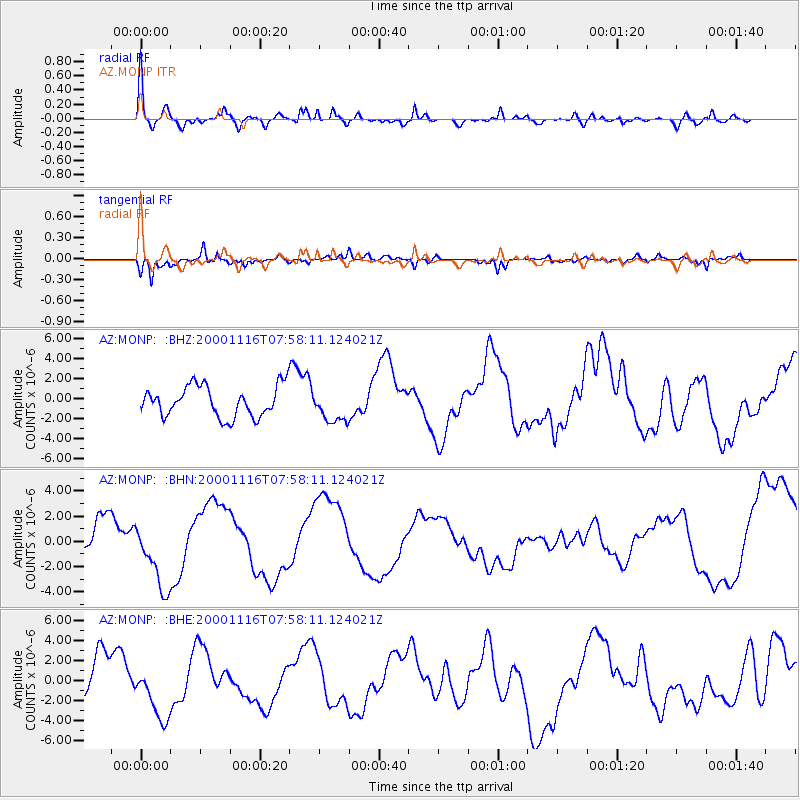
Signal To Noise
| Channel | StoN | STA | LTA |
| AZ:MONP: :BHN:20001116T07:58:11.124021Z | 1.5693681 | 2.501854E-6 | 1.5941791E-6 |
| AZ:MONP: :BHE:20001116T07:58:11.124021Z | 1.2392482 | 2.623637E-6 | 2.11712E-6 |
| AZ:MONP: :BHZ:20001116T07:58:11.124021Z | 1.0766925 | 1.6498311E-6 | 1.5323142E-6 |
| Arrivals |
| Ps | 3.7 SECOND |
| PpPs | 13 SECOND |
| PsPs/PpSs | 17 SECOND |


