You are here: Home > Network List > US - United States National Seismic Network Stations List
> Station CBKS Cedar Bluff, Kansas, USA > Earthquake Result Viewer
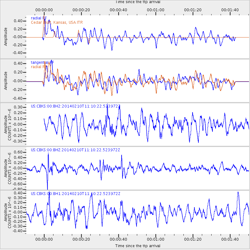
CBKS Cedar Bluff, Kansas, USA - Earthquake Result Viewer
*The percent match for this event was below the threshold and hence no stack was calculated.
| Earthquake location: |
Northern Chile |
| Earthquake latitude/longitude: |
-22.3/-68.7 |
| Earthquake time(UTC): |
2014/02/10 (041) 11:00:09 GMT |
| Earthquake Depth: |
107 km |
| Earthquake Magnitude: |
5.2 MW |
| Earthquake Catalog/Contributor: |
ISC/ISC |
|
| Network: |
US United States National Seismic Network |
| Station: |
CBKS Cedar Bluff, Kansas, USA |
| Lat/Lon: |
38.81 N/99.74 W |
| Elevation: |
677 m |
|
| Distance: |
67.4 deg |
| Az: |
334.093 deg |
| Baz: |
148.795 deg |
| Ray Param: |
$rayparam |
*The percent match for this event was below the threshold and hence was not used in the summary stack. |
|
| Radial Match: |
47.92308 % |
| Radial Bump: |
400 |
| Transverse Match: |
51.646336 % |
| Transverse Bump: |
400 |
| SOD ConfigId: |
3390531 |
| Insert Time: |
2019-04-10 07:11:22.962 +0000 |
| GWidth: |
2.5 |
| Max Bumps: |
400 |
| Tol: |
0.001 |
|
Signal To Noise
| Channel | StoN | STA | LTA |
| US:CBKS:00:BHZ:20140210T11:10:22.523972Z | 2.1154003 | 2.3465131E-7 | 1.1092524E-7 |
| US:CBKS:00:BH1:20140210T11:10:22.523972Z | 1.884441 | 2.0790313E-7 | 1.1032615E-7 |
| US:CBKS:00:BH2:20140210T11:10:22.523972Z | 1.0359033 | 1.2595258E-7 | 1.2158719E-7 |
| Arrivals |
| Ps | |
| PpPs | |
| PsPs/PpSs | |


