You are here: Home > Network List > AZ - ANZA Regional Network Stations List
> Station MONP AZ.MONP > Earthquake Result Viewer
MONP AZ.MONP - Earthquake Result Viewer
| Earthquake location: |
Windward Islands |
| Earthquake latitude/longitude: |
11.1/-62.6 |
| Earthquake time(UTC): |
2000/10/04 (278) 14:37:44 GMT |
| Earthquake Depth: |
110 km |
| Earthquake Magnitude: |
5.6 MB, 5.4 MS, 6.1 MW, 5.9 MD |
| Earthquake Catalog/Contributor: |
WHDF/NEIC |
|
| Network: |
AZ ANZA Regional Network |
| Station: |
MONP AZ.MONP |
| Lat/Lon: |
32.89 N/116.42 W |
| Elevation: |
1920 m |
|
| Distance: |
53.8 deg |
| Az: |
302.649 deg |
| Baz: |
100.824 deg |
| Ray Param: |
0.06551146 |
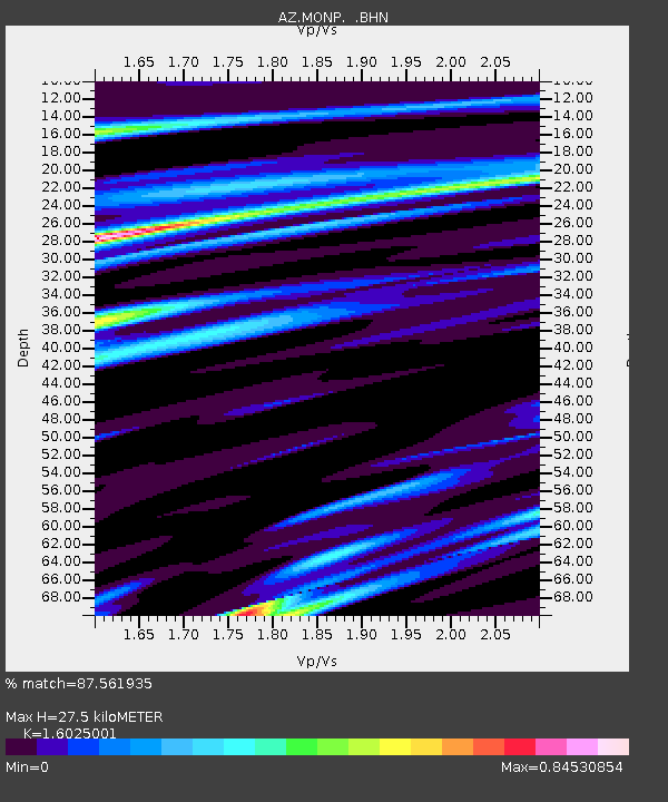
| Estimated Moho Depth: |
27.5 km |
| Estimated Crust Vp/Vs: |
1.60 |
| Assumed Crust Vp: |
6.264 km/s |
| Estimated Crust Vs: |
3.909 km/s |
| Estimated Crust Poisson's Ratio: |
0.18 |
|
| Radial Match: |
87.561935 % |
| Radial Bump: |
391 |
| Transverse Match: |
71.998116 % |
| Transverse Bump: |
400 |
| SOD ConfigId: |
3744 |
| Insert Time: |
2010-02-26 20:01:53.282 +0000 |
| GWidth: |
2.5 |
| Max Bumps: |
400 |
| Tol: |
0.001 |
|
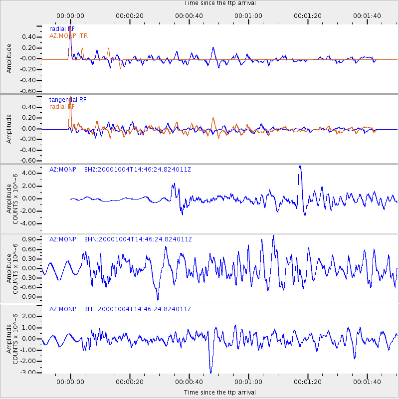
Signal To Noise
| Channel | StoN | STA | LTA |
| AZ:MONP: :BHN:20001004T14:46:24.824011Z | 1.0495824 | 2.0642004E-7 | 1.9666874E-7 |
| AZ:MONP: :BHE:20001004T14:46:24.824011Z | 1.8035785 | 3.812089E-7 | 2.1136253E-7 |
| AZ:MONP: :BHZ:20001004T14:46:24.824011Z | 4.3284664 | 7.685349E-7 | 1.7755363E-7 |
| Arrivals |
| Ps | 2.8 SECOND |
| PpPs | 11 SECOND |
| PsPs/PpSs | 14 SECOND |


