You are here: Home > Network List > XG92 - Rocky Mountain Front Stations List
> Station WIG Orchard, CO > Earthquake Result Viewer
WIG Orchard, CO - Earthquake Result Viewer
| Earthquake location: |
Svalbard Region |
| Earthquake latitude/longitude: |
78.5/5.1 |
| Earthquake time(UTC): |
1992/07/20 (202) 07:46:46 GMT |
| Earthquake Depth: |
10 km |
| Earthquake Magnitude: |
5.8 MB, 6.3 MS |
| Earthquake Catalog/Contributor: |
WHDF/NEIC |
|
| Network: |
XG Rocky Mountain Front |
| Station: |
WIG Orchard, CO |
| Lat/Lon: |
40.33 N/104.07 W |
| Elevation: |
1368 m |
|
| Distance: |
54.5 deg |
| Az: |
297.443 deg |
| Baz: |
13.507 deg |
| Ray Param: |
0.06542377 |
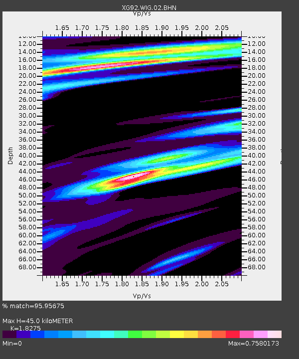
| Estimated Moho Depth: |
45.0 km |
| Estimated Crust Vp/Vs: |
1.83 |
| Assumed Crust Vp: |
6.306 km/s |
| Estimated Crust Vs: |
3.451 km/s |
| Estimated Crust Poisson's Ratio: |
0.29 |
|
| Radial Match: |
95.95675 % |
| Radial Bump: |
306 |
| Transverse Match: |
86.7762 % |
| Transverse Bump: |
384 |
| SOD ConfigId: |
3286 |
| Insert Time: |
2010-02-25 20:11:59.752 +0000 |
| GWidth: |
2.5 |
| Max Bumps: |
400 |
| Tol: |
0.001 |
|
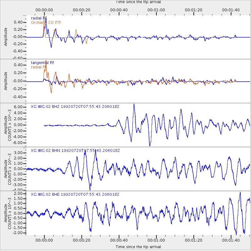
Signal To Noise
| Channel | StoN | STA | LTA |
| XG:WIG:02:BHN:19920720T07:55:43.206018Z | 1.281646 | 1.5892758E-4 | 1.240027E-4 |
| XG:WIG:02:BHE:19920720T07:55:43.206018Z | 2.3607168 | 2.5618414E-4 | 1.0851964E-4 |
| XG:WIG:02:BHZ:19920720T07:55:43.206018Z | 2.5803728 | 2.2030323E-4 | 8.5376516E-5 |
| Arrivals |
| Ps | 6.2 SECOND |
| PpPs | 19 SECOND |
| PsPs/PpSs | 25 SECOND |


