You are here: Home > Network List > AZ - ANZA Regional Network Stations List
> Station MONP AZ.MONP > Earthquake Result Viewer
MONP AZ.MONP - Earthquake Result Viewer

| Earthquake location: |
Tonga Islands |
| Earthquake latitude/longitude: |
-17.2/-173.9 |
| Earthquake time(UTC): |
2000/09/26 (270) 06:17:52 GMT |
| Earthquake Depth: |
56 km |
| Earthquake Magnitude: |
6.1 MB, 6.1 MS, 6.4 MW, 6.1 ME |
| Earthquake Catalog/Contributor: |
WHDF/NEIC |
|
| Network: |
AZ ANZA Regional Network |
| Station: |
MONP AZ.MONP |
| Lat/Lon: |
32.89 N/116.42 W |
| Elevation: |
1920 m |
|
| Distance: |
74.1 deg |
| Az: |
47.539 deg |
| Baz: |
236.953 deg |
| Ray Param: |
0.052427128 |
| Estimated Moho Depth: |
30.5 km |
| Estimated Crust Vp/Vs: |
1.75 |
| Assumed Crust Vp: |
6.264 km/s |
| Estimated Crust Vs: |
3.579 km/s |
| Estimated Crust Poisson's Ratio: |
0.26 |
|
| Radial Match: |
85.651695 % |
| Radial Bump: |
400 |
| Transverse Match: |
81.79594 % |
| Transverse Bump: |
400 |
| SOD ConfigId: |
3744 |
| Insert Time: |
2010-02-26 20:01:56.166 +0000 |
| GWidth: |
2.5 |
| Max Bumps: |
400 |
| Tol: |
0.001 |
|
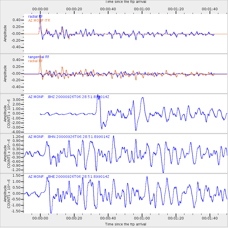
Signal To Noise
| Channel | StoN | STA | LTA |
| AZ:MONP: :BHN:20000926T06:28:51.899014Z | 4.598384 | 3.816175E-7 | 8.298948E-8 |
| AZ:MONP: :BHE:20000926T06:28:51.899014Z | 4.290313 | 6.256901E-7 | 1.4583787E-7 |
| AZ:MONP: :BHZ:20000926T06:28:51.899014Z | 13.346884 | 1.8013246E-6 | 1.3496219E-7 |
| Arrivals |
| Ps | 3.8 SECOND |
| PpPs | 13 SECOND |
| PsPs/PpSs | 17 SECOND |


