You are here: Home > Network List > AZ - ANZA Regional Network Stations List
> Station MONP AZ.MONP > Earthquake Result Viewer
MONP AZ.MONP - Earthquake Result Viewer

| Earthquake location: |
Vanuatu Islands |
| Earthquake latitude/longitude: |
-15.7/168.0 |
| Earthquake time(UTC): |
2000/08/09 (222) 00:08:41 GMT |
| Earthquake Depth: |
33 km |
| Earthquake Magnitude: |
6.3 MB, 6.0 MS, 6.4 MW, 6.3 MW |
| Earthquake Catalog/Contributor: |
WHDF/NEIC |
|
| Network: |
AZ ANZA Regional Network |
| Station: |
MONP AZ.MONP |
| Lat/Lon: |
32.89 N/116.42 W |
| Elevation: |
1920 m |
|
| Distance: |
86.8 deg |
| Az: |
54.704 deg |
| Baz: |
249.129 deg |
| Ray Param: |
0.043767598 |
| Estimated Moho Depth: |
66.25 km |
| Estimated Crust Vp/Vs: |
1.82 |
| Assumed Crust Vp: |
6.264 km/s |
| Estimated Crust Vs: |
3.451 km/s |
| Estimated Crust Poisson's Ratio: |
0.28 |
|
| Radial Match: |
83.55435 % |
| Radial Bump: |
400 |
| Transverse Match: |
82.887886 % |
| Transverse Bump: |
400 |
| SOD ConfigId: |
3744 |
| Insert Time: |
2010-02-26 20:01:57.474 +0000 |
| GWidth: |
2.5 |
| Max Bumps: |
400 |
| Tol: |
0.001 |
|
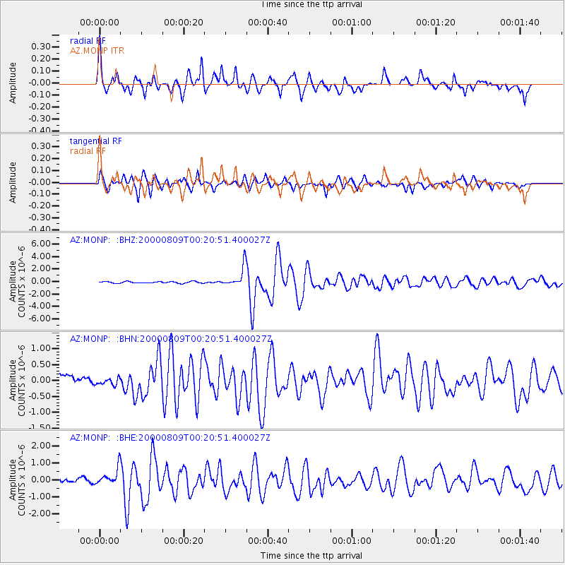
Signal To Noise
| Channel | StoN | STA | LTA |
| AZ:MONP: :BHN:20000809T00:20:51.400027Z | 0.5444371 | 1.0218132E-7 | 1.8768249E-7 |
| AZ:MONP: :BHE:20000809T00:20:51.400027Z | 3.4992554 | 5.5544933E-7 | 1.5873357E-7 |
| AZ:MONP: :BHZ:20000809T00:20:51.400027Z | 12.9505625 | 1.6782097E-6 | 1.2958586E-7 |
| Arrivals |
| Ps | 8.8 SECOND |
| PpPs | 29 SECOND |
| PsPs/PpSs | 38 SECOND |


